
Bynack Burn


Archaeological Landscape (Post Medieval)
Site Name Bynack Burn
Classification Archaeological Landscape (Post Medieval)
Alternative Name(s) Mar Lodge Estate; Bynack Lodge To Ruigh Nan Clach
Canmore ID 81212
Site Number NO08NW 19
NGR NO 004 861
Datum OSGB36 - NGR
Permalink http://canmore.org.uk/site/81212


- Council Aberdeenshire
- Parish Crathie And Braemar
- Former Region Grampian
- Former District Kincardine And Deeside
- Former County Aberdeenshire
Field Visit (20 July 1993)
NO08NW 19.00 centred 004 861
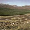
Six groups of shieling-huts and various pens are scattered along the valley bottom and sides on the E bank of the Bynack Burn from near Bynack Lodge in the S to the confluence of the Bynack and Geldie Burns in the N. The same area is partially enclosed by a dyke, which also runs down the W side of the Bynack Burn to a sheepfold and sheep-dip on the S of the Geldie Burn.
19.01 NO 0023 8573 Shieling-huts (MAR93 513-20)
19.02 NO 0036 8611 Shieling-huts (MAR93 526-28)
19.03 NO 0048 8611 Shieling-huts (MAR93 529-33)
19.04 NO 0052 8643 Shieling-huts (MAR93 534-38)
19.05 NO 0063 8669 Shieling-huts (MAR93 539-43)
19.06 NO 0085 8665 Shieling-huts;Sheepfolds; Pens (MAR93 544-49, 553-4, 564-5, 615, 616)
19.07 NO 0042 8673 Boundary-dyke; Sheepfold; Sheep-dip; Bothy (MAR93 551-2)
19.08 NO 0068 6843 Platform; Platform (possible) (MAR93 618)
19.09 NO 0034 8668 Pen; Shooting Butt (possible) (MAR93 619)
Visited by RCAHMS (PJD) 20 July 1993.

