
Following the launch of trove.scot in February 2025 we are now planning the retiral of some of our webservices. Canmore will be switched off on 24th June 2025. Information about the closure can be found on the HES website: Retiral of HES web services | Historic Environment Scotland
Mains Of Rhynie


Cropmark(S) (Period Unknown), Pit(S) (Period Unassigned), Square Barrow(S) (Iron Age)(Possible)
Site Name Mains Of Rhynie
Classification Cropmark(S) (Period Unknown), Pit(S) (Period Unassigned), Square Barrow(S) (Iron Age)(Possible)
Canmore ID 80306
Site Number NJ42NE 61
NGR NJ 4960 2655
Datum OSGB36 - NGR
Permalink http://canmore.org.uk/site/80306


- Council Aberdeenshire
- Parish Rhynie
- Former Region Grampian
- Former District Gordon
- Former County Aberdeenshire
NJ42NE 61 4960 2655
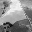
Air photography (AAS/92/02/S5/7, 10 and 12-15, dated 20 February 1992) has recorded indeterminate cropmarks and those of possible square barrows in arable ground on a gentle N-facing slope at an altitude of 200m OD.
Information from Aberdeenshire Archaeological Service, June 1997.
NMRS, MS/712/19.
Magnetometry (29 January 2024 - 23 February 2024)
NJ 49140 26553 Headland Archaeology Ltd was commissioned to undertake a geophysical (magnetometer) survey on land at Mains of Rhynie, Rhynie, Aberdeenshire.
A wide range of magnetic anomalies have been recorded against a variable magnetic background although an oval enclosure, located towards the centre of the site, is the only anomaly of clear archaeological potential. This anomaly clearly correlates with a cropmark interpreted as a possible prehistoric palisaded enclosure. This feature is similar in form to a larger concentric oval enclosure surrounding the Craw Stane monument 0.5km to the east of the site.
A series of faint linear trend anomalies, possibly forming enclosures, in the north of the site are determined of uncertain or possible archaeological origin. These and clusters of magnetically enhanced discrete anomalies, are too weak and/or diffuse to interpret with a greater level of confidence but collectively they might locate an area of archaeological potential although this interpretation is tentative. Several other discrete anomalies are also interpreted as of uncertain origin. Small areas of magnetic enhancement and disturbance at the northern tip and eastern boundary of the site locate a former cottage and sheepfold recorded on historic mapping.
The remaining magnetic anomalies are of likely agricultural origin, identifying cultivation patterns and/or field drains, or are natural/geological in origin also likely reflecting the localised topographic variations across the site.
Information from C. Adams, C. and M. Berry – Headland Archaeology Ltd, 2024.
OASIS ID: headland1-523419

