
Fife Ness, Lighthouse Construction Site


Lighthouse Construction Yard (19th Century)
Site Name Fife Ness, Lighthouse Construction Site
Classification Lighthouse Construction Yard (19th Century)
Alternative Name(s) North Carr Rock
Canmore ID 78221
Site Number NO60NW 33.01
NGR NO 6367 0985
Datum OSGB36 - NGR
Permalink http://canmore.org.uk/site/78221


- Council Fife
- Parish Crail
- Former Region Fife
- Former District North East Fife
- Former County Fife
NO60NW 33.01 6367 0985
See also NO60NW 9.
Base for construction work on Robert Stevenson's lighthouse for North Carr Rocks. Consists of circular indentation in rock (sandstone)
Site recorded by Maritime Fife during the Coastal Assessment Survey for Historic Scotland, Fife Ness to Newburgh 1996
Ground Survey (1 June 2011 - 30 September 2011)
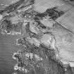
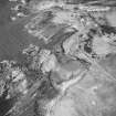
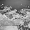
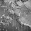
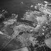
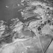
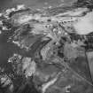
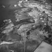
NO 6367 0985 A survey of rock-cut features on Fife Ness associated with the building of a beacon at the end of the adjacent Carr rocks by Robert Stevenson in 1813-17 was conducted, between 1 June–30 September 2011, using rectified vertical photographs obtained with an aerial drone. The features comprise a partially collapsed rubble quay 23m wide and up to 3m high at the edge of a natural creek, recorded as a harbour or haven since the 17th century. The quay runs lengthwise from N to S. Close to its centre a roughly circular structure some 4m in diameter, built of roughly-squared blocks has been identified as the footing of a circular crane base built into the top of the quay. 30m to the W, on a rock platform which appears to have been artificially levelled, is a rock-cut circular feature with a central boss which appears to be a crane base of similar size to the one on the quay. Beside this feature, curving towards the crane base on the quay is a series of paired holes, which can be identified as anchor points for a tubway similar to that used by Stevenson during the building of the Bell Rock light some years earlier. The tubway holes cease some 10m short of the quay, where the rock surface drops away, suggesting that some kind of elevated arrangement for the track had been provided here. There are holes elsewhere on the platform whose function is not clear.
On either side of the western crane base are rock-cut segments of circles which may be identified as setting-out jigs for cutting and trimming the interlocking stone courses before shipping them out for assembly on the reef, a process recorded by Stevenson. Two discarded interlocking stones have been identified on the foreshore, and one has been preserved. Some distance to the S a small circular pool with a well-dressed masonry surround has been identified as a quenching bath for the constant task of sharpening and tempering the masons’ tools.
Great difficulty was experienced in erecting the beacon tower, since the lower courses were repeatedly knocked down by heavy seas. Shortly after completion in 1817 the whole upper tower collapsed, and a short cast-iron beacon was built on the surviving foundation courses. This structure is still extant.
Archive: RCAHMS (intended)
Morvern Maritime centre and Edward Martin Photography, 2011

