
Following the launch of trove.scot in February 2025 we are now planning the retiral of some of our webservices. Canmore will be switched off on 24th June 2025. Information about the closure can be found on the HES website: Retiral of HES web services | Historic Environment Scotland
Haddo House


Farmhouse (Period Unassigned)
Site Name Haddo House
Classification Farmhouse (Period Unassigned)
Alternative Name(s) Haddo; Mains Of Haddo
Canmore ID 77139
Site Number NK05NE 14
NGR NK 07750 57166
Datum OSGB36 - NGR
Permalink http://canmore.org.uk/site/77139
Ordnance Survey licence number AC0000807262. All rights reserved.
Canmore Disclaimer.
© Bluesky International Limited 2025. Public Sector Viewing Terms
- Correction
- Favourite

DP 217724
Oblique aerial view of Haddo House, steading and walled garden, looking NNW.
RCAHMS Aerial Photography Digital
30/7/2015
© Crown Copyright: HES

DP 217725
Oblique aerial view of Haddo House, steading and walled garden, looking WNW.
RCAHMS Aerial Photography Digital
30/7/2015
© Crown Copyright: HES

DP 217726
Oblique aerial view of Haddo House, steading and walled garden, looking W.
RCAHMS Aerial Photography Digital
30/7/2015
© Crown Copyright: HES

SC 1507591
View from East showing rear wing of main house, kitchen wing and timber porch
Records of the Royal Commission on the Ancient and Historical Monuments of Scotland (RCAHMS), Edinbu
26/5/1999
© Crown Copyright: HES

SC 1507592
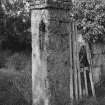
View of gate piers from South East
Records of the Royal Commission on the Ancient and Historical Monuments of Scotland (RCAHMS), Edinbu
26/5/1999
© Crown Copyright: HES

SC 1507597
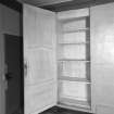
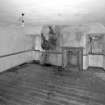
Interior.View of ground floor South room/ parlour from North showing a detail of the cupboard concealed behind panelling to the East of the fireplace formed in a blocked window embrasure.
Records of the Royal Commission on the Ancient and Historical Monuments of Scotland (RCAHMS), Edinbu
26/5/1999
© Crown Copyright: HES

SC 1507626
Interior. View of first floor North room/principal bedroom showing detail of cupboard behind the panelling
Records of the Royal Commission on the Ancient and Historical Monuments of Scotland (RCAHMS), Edinbu
26/5/1999
© Crown Copyright: HES

SC 1507630
Interior. View of first floor North room/principal bedroom from South showing panelling and fireplace
Records of the Royal Commission on the Ancient and Historical Monuments of Scotland (RCAHMS), Edinbu
26/5/1999
© Crown Copyright: HES

SC 1507631
Interior. Ground floor South room/parlour detail of window and sun blind
Records of the Royal Commission on the Ancient and Historical Monuments of Scotland (RCAHMS), Edinbu
26/5/1999
© Crown Copyright: HES

SC 1507638
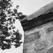
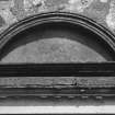
Detail of semicircular pediment above entrance
Records of the Royal Commission on the Ancient and Historical Monuments of Scotland (RCAHMS), Edinbu
26/5/1999
© Crown Copyright: HES

SC 2516032
View of kitchen wing and servicve yard from North
Records of the Royal Commission on the Ancient and Historical Monuments of Scotland (RCAHMS), Edinbu
26/5/1999
© Crown Copyright: HES

SC 2516037
Interior. View of kitchen from West showing arched recess for aga
Records of the Royal Commission on the Ancient and Historical Monuments of Scotland (RCAHMS), Edinbu
26/5/1999
© Crown Copyright: HES

SC 2516043
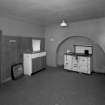
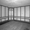
Interior.View of ground floor /North room dining room from South showing sideboard recess, fireplace and panelling
Records of the Royal Commission on the Ancient and Historical Monuments of Scotland (RCAHMS), Edinbu
26/5/1999
© Crown Copyright: HES

SC 2516061
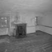
Interior. View of second floor North room from South showing coombed ceiling and fireplace
Records of the Royal Commission on the Ancient and Historical Monuments of Scotland (RCAHMS), Edinbu
26/5/1999
© Crown Copyright: HES

SC 2516065
Interior. Detail of staircase fluted newel post
Records of the Royal Commission on the Ancient and Historical Monuments of Scotland (RCAHMS), Edinbu
26/5/1999
© Crown Copyright: HES

SC 2516066
Interior. Detail of incised decoration on the staircase stringer
Records of the Royal Commission on the Ancient and Historical Monuments of Scotland (RCAHMS), Edinbu
26/5/1999
© Crown Copyright: HES

SC 2516087
Detail of blind oculus above entrance
Records of the Royal Commission on the Ancient and Historical Monuments of Scotland (RCAHMS), Edinbu
26/5/1999
© Crown Copyright: HES

SC 2516088
Detail of Northwest skewputt
Records of the Royal Commission on the Ancient and Historical Monuments of Scotland (RCAHMS), Edinbu
26/5/1999
© Crown Copyright: HES


DP 137618
View from south west
Records of the Royal Commission on the Ancient and Historical Monuments of Scotland (RCAHMS), Edinbu
29/6/2012
© Crown Copyright: HES

DP 217731
Oblique aerial view of Haddo House, steading and walled garden, looking NE.
RCAHMS Aerial Photography Digital
30/7/2015
© Crown Copyright: HES

SC 1507594
Interior. View of kitchen from West showing arched recess for aga
Records of the Royal Commission on the Ancient and Historical Monuments of Scotland (RCAHMS), Edinbu
26/5/1999
© Crown Copyright: HES

SC 1507602
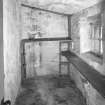
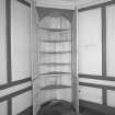
Interior. View of ground floor larder
Records of the Royal Commission on the Ancient and Historical Monuments of Scotland (RCAHMS), Edinbu
26/5/1999
© Crown Copyright: HES

SC 1507608
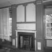
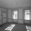
Interior. View of first floor South room/ drawing room from North showing fireplace flanked by giant fluted pilastersand Nineteenth Century grate
Records of the Royal Commission on the Ancient and Historical Monuments of Scotland (RCAHMS), Edinbu
26/5/1999
© Crown Copyright: HES

SC 1507609
Interior. View of first floor North room/principal bedroom from South showing panelling and fireplace
Records of the Royal Commission on the Ancient and Historical Monuments of Scotland (RCAHMS), Edinbu
26/5/1999
© Crown Copyright: HES

SC 1507613
Interior. View of second floor South room from North showing coombed ceiling and fireplace
Records of the Royal Commission on the Ancient and Historical Monuments of Scotland (RCAHMS), Edinbu
26/5/1999
© Crown Copyright: HES

SC 1507614
Interior. View of second floor North room from South showing coombed ceiling and fireplace
Records of the Royal Commission on the Ancient and Historical Monuments of Scotland (RCAHMS), Edinbu
26/5/1999
© Crown Copyright: HES

SC 1507616
Interior. View of second floor East room/housekeepers room from North showing fireplace and fitted cupboards.
Records of the Royal Commission on the Ancient and Historical Monuments of Scotland (RCAHMS), Edinbu
26/5/1999
© Crown Copyright: HES

SC 1507623
Interior, First floor drawing room detail of four panelled door
Records of the Royal Commission on the Ancient and Historical Monuments of Scotland (RCAHMS), Edinbu
26/5/1999
© Crown Copyright: HES

SC 1507624
Interior.View of ground floor North room/ dining room detail of panelling
Records of the Royal Commission on the Ancient and Historical Monuments of Scotland (RCAHMS), Edinbu
26/5/1999
© Crown Copyright: HES

SC 1507629
Interior.View of ground floor /North room dining room from South showing fireplace and panelling
Records of the Royal Commission on the Ancient and Historical Monuments of Scotland (RCAHMS), Edinbu
26/5/1999
© Crown Copyright: HES

SC 2516029
View from North showing North and East elevations
Records of the Royal Commission on the Ancient and Historical Monuments of Scotland (RCAHMS), Edinbu
26/5/1999
© Crown Copyright: HES

SC 2516036
View of gate piers from South
Records of the Royal Commission on the Ancient and Historical Monuments of Scotland (RCAHMS), Edinbu
26/5/1999
© Crown Copyright: HES

SC 2516040
Interior.View of ground floor South room/ parlour showing a detail of the panelling
Records of the Royal Commission on the Ancient and Historical Monuments of Scotland (RCAHMS), Edinbu
26/5/1999
© Crown Copyright: HES

SC 2516052
Interior. View of first floor South room/ drawing room from North showing fireplace flanked by giant fluted pilasters, panelling and windows
Records of the Royal Commission on the Ancient and Historical Monuments of Scotland (RCAHMS), Edinbu
26/5/1999
© Crown Copyright: HES

SC 2516055
Interior. View of first floor South room/ drawing room from North showing fireplace flanked by giant fluted pilastersand Nineteenth Century grate
Records of the Royal Commission on the Ancient and Historical Monuments of Scotland (RCAHMS), Edinbu
26/5/1999
© Crown Copyright: HES

SC 2516056
Interior. View of first floor North room/principal bedroom from South showing panelling and fireplace
Records of the Royal Commission on the Ancient and Historical Monuments of Scotland (RCAHMS), Edinbu
26/5/1999
© Crown Copyright: HES

SC 2516057
Interior. View of first floor North East room/ dressing room from West showing fireplace
Records of the Royal Commission on the Ancient and Historical Monuments of Scotland (RCAHMS), Edinbu
26/5/1999
© Crown Copyright: HES

SC 2516069
Interior. Detail of front door drawbar and metalwork
Records of the Royal Commission on the Ancient and Historical Monuments of Scotland (RCAHMS), Edinbu
26/5/1999
© Crown Copyright: HES

SC 2516077
Interior. View of first floor North room/principal bedroom from South showing panelling and fireplace
Records of the Royal Commission on the Ancient and Historical Monuments of Scotland (RCAHMS), Edinbu
26/5/1999
© Crown Copyright: HES

SC 2516078
Interior. Ground floor South room/parlour detail of window and sun blind
Records of the Royal Commission on the Ancient and Historical Monuments of Scotland (RCAHMS), Edinbu
26/5/1999
© Crown Copyright: HES

SC 2516081
Interior. First floor drawing room detail brass rim lock
Records of the Royal Commission on the Ancient and Historical Monuments of Scotland (RCAHMS), Edinbu
26/5/1999
© Crown Copyright: HES

SC 2516085
Detail of semicircular pediment above entrance
Records of the Royal Commission on the Ancient and Historical Monuments of Scotland (RCAHMS), Edinbu
26/5/1999
© Crown Copyright: HES

SC 2516089
Detail of gate pier
Records of the Royal Commission on the Ancient and Historical Monuments of Scotland (RCAHMS), Edinbu
26/5/1999
© Crown Copyright: HES


DP 217723
Oblique aerial view of Haddo House, steading and walled garden, looking N.
RCAHMS Aerial Photography Digital
30/7/2015
© Crown Copyright: HES

DP 217732
Oblique aerial view of Haddo House, steading and walled garden, looking NNE.
RCAHMS Aerial Photography Digital
30/7/2015
© Crown Copyright: HES

SC 1507590
View of kitchen wing and servicve yard from North
Records of the Royal Commission on the Ancient and Historical Monuments of Scotland (RCAHMS), Edinbu
26/5/1999
© Crown Copyright: HES

SC 1507603
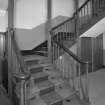
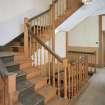
Interior. View of half turn with landings staircase at ground floor level showing fluted newel posts and turned balusters
Records of the Royal Commission on the Ancient and Historical Monuments of Scotland (RCAHMS), Edinbu
26/5/1999
© Crown Copyright: HES

SC 1507627
Interior. View of first floor South room/ drawing room showing a detail of the cornice and pilaster capital
Records of the Royal Commission on the Ancient and Historical Monuments of Scotland (RCAHMS), Edinbu
26/5/1999
© Crown Copyright: HES

SC 1507628
Interior. View of first floor South room/ drawing room from West showing closed china closet and panelling
Records of the Royal Commission on the Ancient and Historical Monuments of Scotland (RCAHMS), Edinbu
26/5/1999
© Crown Copyright: HES

SC 1507636
Detail of timber porch
Records of the Royal Commission on the Ancient and Historical Monuments of Scotland (RCAHMS), Edinbu
26/5/1999
© Crown Copyright: HES

SC 2516023
View from South West showing entrance front
Records of the Royal Commission on the Ancient and Historical Monuments of Scotland (RCAHMS), Edinbu
26/5/1999
© Crown Copyright: HES

SC 2516042
Interior.View of ground floor North room dining room from South showing sideboard recess, fireplace and panelling
Records of the Royal Commission on the Ancient and Historical Monuments of Scotland (RCAHMS), Edinbu
26/5/1999
© Crown Copyright: HES

SC 2516053
Interior. View of first floor South room/ drawing room from North showing fireplace flanked by giant fluted pilasters, panelling and windows
Records of the Royal Commission on the Ancient and Historical Monuments of Scotland (RCAHMS), Edinbu
26/5/1999
© Crown Copyright: HES

SC 2516054
Interior. View of first floor South room/ drawing room from West showing closed china closet and panelling
Records of the Royal Commission on the Ancient and Historical Monuments of Scotland (RCAHMS), Edinbu
26/5/1999
© Crown Copyright: HES

SC 2516063
Interior. View of second floor East room/housekeepers room from North showing fireplace and fitted cupboards.
Records of the Royal Commission on the Ancient and Historical Monuments of Scotland (RCAHMS), Edinbu
26/5/1999
© Crown Copyright: HES

SC 2516084
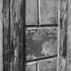
Detail of tmber panelling on porch designed to look like ashlar stonework
Records of the Royal Commission on the Ancient and Historical Monuments of Scotland (RCAHMS), Edinbu
26/5/1999
© Crown Copyright: HES


SC 1507589
View from South showing garden South elevation
Records of the Royal Commission on the Ancient and Historical Monuments of Scotland (RCAHMS), Edinbu
26/5/1999
© Crown Copyright: HES

SC 1507593
View of gate piers from South
Records of the Royal Commission on the Ancient and Historical Monuments of Scotland (RCAHMS), Edinbu
26/5/1999
© Crown Copyright: HES

SC 1507599
Interior.View of ground floor/ North room dining room from West showing windows, two panelled door and panelling
Records of the Royal Commission on the Ancient and Historical Monuments of Scotland (RCAHMS), Edinbu
26/5/1999
© Crown Copyright: HES

SC 1507601
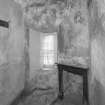
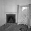
Interior. View of room off ground floor South room/parlour from West showing fireplace
Records of the Royal Commission on the Ancient and Historical Monuments of Scotland (RCAHMS), Edinbu
26/5/1999
© Crown Copyright: HES

SC 1507604
Interior. View of half turn with landings staircase at first floor level showing fluted newel posts and turned balusters
Records of the Royal Commission on the Ancient and Historical Monuments of Scotland (RCAHMS), Edinbu
26/5/1999
© Crown Copyright: HES

SC 1507606
Interior. View of first floor South room/ drawing room from West showing closed china closet and panelling
Records of the Royal Commission on the Ancient and Historical Monuments of Scotland (RCAHMS), Edinbu
26/5/1999
© Crown Copyright: HES

SC 1507618
Interior. Detail of staircase fluted newel post
Records of the Royal Commission on the Ancient and Historical Monuments of Scotland (RCAHMS), Edinbu
26/5/1999
© Crown Copyright: HES

SC 1507639
Detail of incised key motif on pediment with five keys
Records of the Royal Commission on the Ancient and Historical Monuments of Scotland (RCAHMS), Edinbu
26/5/1999
© Crown Copyright: HES

SC 2516024
View from West showing entrance front
Records of the Royal Commission on the Ancient and Historical Monuments of Scotland (RCAHMS), Edinbu
26/5/1999
© Crown Copyright: HES

SC 2516026
View from West North West showing entrance front
Records of the Royal Commission on the Ancient and Historical Monuments of Scotland (RCAHMS), Edinbu
26/5/1999
© Crown Copyright: HES

SC 2516028
View from West North West showing front porch and blind oculus above
Records of the Royal Commission on the Ancient and Historical Monuments of Scotland (RCAHMS), Edinbu
26/5/1999
© Crown Copyright: HES

SC 2516039
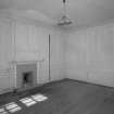
Interior.View of ground floor South room/ parlour from North showing the fireplace and panelling
Records of the Royal Commission on the Ancient and Historical Monuments of Scotland (RCAHMS), Edinbu
26/5/1999
© Crown Copyright: HES

SC 2516060
Interior. View of second floor South room from North showing coombed ceiling and fireplace
Records of the Royal Commission on the Ancient and Historical Monuments of Scotland (RCAHMS), Edinbu
26/5/1999
© Crown Copyright: HES

SC 2516068
Interior. Detail of top of staircase fluted newel post
Records of the Royal Commission on the Ancient and Historical Monuments of Scotland (RCAHMS), Edinbu
26/5/1999
© Crown Copyright: HES


DP 137619
View from south west
Records of the Royal Commission on the Ancient and Historical Monuments of Scotland (RCAHMS), Edinbu
29/6/2012
© Crown Copyright: HES

DP 217728
Oblique aerial view of Haddo House, steading and walled garden, looking SSW.
RCAHMS Aerial Photography Digital
30/7/2015
© Crown Copyright: HES

SC 1507584
View from South West showing entrance front
Records of the Royal Commission on the Ancient and Historical Monuments of Scotland (RCAHMS), Edinbu
26/5/1999
© Crown Copyright: HES

SC 1507600
Interior. View of ground floor North East room from West showing panelling and fireplace
Records of the Royal Commission on the Ancient and Historical Monuments of Scotland (RCAHMS), Edinbu
26/5/1999
© Crown Copyright: HES

SC 1507607
Interior. View of first floor South room/ drawing room from West showing china closet open with its closing pin
Records of the Royal Commission on the Ancient and Historical Monuments of Scotland (RCAHMS), Edinbu
26/5/1999
© Crown Copyright: HES

SC 1507637
Detail of tmber panelling on porch designed to look like ashlar stonework
Records of the Royal Commission on the Ancient and Historical Monuments of Scotland (RCAHMS), Edinbu
26/5/1999
© Crown Copyright: HES

SC 1507641
Detail of Northwest skewputt
Records of the Royal Commission on the Ancient and Historical Monuments of Scotland (RCAHMS), Edinbu
26/5/1999
© Crown Copyright: HES

SC 1507642
Detail of gate pier
Records of the Royal Commission on the Ancient and Historical Monuments of Scotland (RCAHMS), Edinbu
26/5/1999
© Crown Copyright: HES

SC 2516031
View from South showing garden South elevation
Records of the Royal Commission on the Ancient and Historical Monuments of Scotland (RCAHMS), Edinbu
26/5/1999
© Crown Copyright: HES

SC 2516038
Interior.View of ground floor South room/ parlour from North showing the fireplace and panelling
Records of the Royal Commission on the Ancient and Historical Monuments of Scotland (RCAHMS), Edinbu
26/5/1999
© Crown Copyright: HES

SC 2516046
Interior. View of room off ground floor South room/parlour from West showing fireplace
Records of the Royal Commission on the Ancient and Historical Monuments of Scotland (RCAHMS), Edinbu
26/5/1999
© Crown Copyright: HES

SC 2516048
Interior. View of half turn with landings staircase at ground floor level showing fluted newel posts and turned balusters
Records of the Royal Commission on the Ancient and Historical Monuments of Scotland (RCAHMS), Edinbu
26/5/1999
© Crown Copyright: HES

SC 2516050
Interior. View of half turn with landings staircase at first floor level showing fluted newel posts and turned balusters
Records of the Royal Commission on the Ancient and Historical Monuments of Scotland (RCAHMS), Edinbu
26/5/1999
© Crown Copyright: HES

SC 2516064
Interior. View of second floor East room/housekeepers room from North fitted cupboards open.
Records of the Royal Commission on the Ancient and Historical Monuments of Scotland (RCAHMS), Edinbu
26/5/1999
© Crown Copyright: HES

SC 2516070
Interior, First floor drawing room detail of four panelled door
Records of the Royal Commission on the Ancient and Historical Monuments of Scotland (RCAHMS), Edinbu
26/5/1999
© Crown Copyright: HES

SC 2516071
Interior.View of ground floor North room/ dining room detail of panelling
Records of the Royal Commission on the Ancient and Historical Monuments of Scotland (RCAHMS), Edinbu
26/5/1999
© Crown Copyright: HES

SC 2516072
Interior.View of ground floor North room dining room from South showing buffet recess
Records of the Royal Commission on the Ancient and Historical Monuments of Scotland (RCAHMS), Edinbu
26/5/1999
© Crown Copyright: HES

SC 2516074
Interior. View of first floor South room/ drawing room showing a detail of the cornice and pilaster capital
Records of the Royal Commission on the Ancient and Historical Monuments of Scotland (RCAHMS), Edinbu
26/5/1999
© Crown Copyright: HES

SC 2516075
Interior. View of first floor South room/ drawing room from West showing closed china closet and panelling
Records of the Royal Commission on the Ancient and Historical Monuments of Scotland (RCAHMS), Edinbu
26/5/1999
© Crown Copyright: HES

SC 2516076
Interior.View of ground floor /North room dining room from South showing fireplace and panelling
Records of the Royal Commission on the Ancient and Historical Monuments of Scotland (RCAHMS), Edinbu
26/5/1999
© Crown Copyright: HES

SC 2516079
Interior. First floor drawing room detail of window
Records of the Royal Commission on the Ancient and Historical Monuments of Scotland (RCAHMS), Edinbu
26/5/1999
© Crown Copyright: HES


First 100 images shown. See the Collections panel (below) for a link to all digital images.
- Council Aberdeenshire
- Parish Crimond
- Former Region Grampian
- Former District Banff And Buchan
- Former County Aberdeenshire
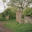
Two storey, seven bay house with attic, rear single storey wings incorporating the U-plan steading.
Information from RCAHMS (2012).
NK05NE 14.00 07750 57166
NK05NE 14.01 07769 57173 Steading
Photographic Survey (29 June 2012)
Photographed on behalf of the Buildings of Scotland publication.

