
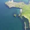
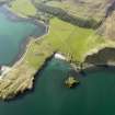
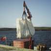
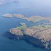
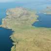
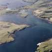
Canna, Pier


Pier (Period Unassigned)
Site Name Canna, Pier
Classification Pier (Period Unassigned)
Alternative Name(s) Canna Harbour
Canmore ID 76068
Site Number NG20NE 27.01
NGR NG 2780 0507
Datum OSGB36 - NGR
Permalink http://canmore.org.uk/site/76068


- Council Highland
- Parish Small Isles
- Former Region Highland
- Former District Lochaber
- Former County Inverness-shire
NG20NE 27.01 2780 0507
Canna Harbour [NAT]
OS 1:10,000 map, 1975.
Built 1892 in timber; widened 1971.
J L Campbell 1984.
(Location amended to NG 2780 0507). There is no change to this record.
Information from RCAHMS (ARG), 13 August 1996.

