
Following the launch of trove.scot in February 2025 we are now planning the retiral of some of our webservices. Canmore will be switched off on 24th June 2025. Information about the closure can be found on the HES website: Retiral of HES web services | Historic Environment Scotland
Woodslee


Burial Cairn (Late Neolithic) - (Bronze Age), Tower House (Medieval)(Possible)
Site Name Woodslee
Classification Burial Cairn (Late Neolithic) - (Bronze Age), Tower House (Medieval)(Possible)
Alternative Name(s) 'Withisleis'; Kinmont Tower
Canmore ID 67549
Site Number NY37SE 7
NGR NY 38923 74125
Datum OSGB36 - NGR
Permalink http://canmore.org.uk/site/67549


- Council Dumfries And Galloway
- Parish Canonbie
- Former Region Dumfries And Galloway
- Former District Annandale And Eskdale
- Former County Dumfries-shire
NY37SE 7 3891 7412.
(NY 3891 7412) Kinmont Tower (NR) (Site of)
OS 6" map (1957)
Published apparently on the authority of local residents (Name Book 1858, as the stronghold owned and occupied by Kinmont Willie (Armstrong), who in fact had Sark, or Morton, which is shown on a map of 1590 as Kinmont Tower (see NY37NW 5).
This is almost certainly the site of one of the two towers shown on the map (Royal MS. 18D iii, Burghley Atlas map 1590) at Woodhouselees (Withisleis). Ebye Armstrong, 'the goodman of Waddusles', is mentioned in 1583. The majority of the many border towers in the area were owned by members of the Armstrong clan.
J and R Hyslop 1912; H Maxwell 1896
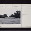
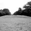
At this site, there is a very large, probably artifical, circular gravelly mound, with a flattish top, which measures about 20 m in diameter and 1 m high, being quarried into on the SE side. It is unlikely to be associated with the quarry to the SE. No trace of any tower exists on the mound, nor could any local information be found regarding the name of the tower.
Resurveyed at 1:2500.
Visited by OS (WDJ) 23 June 1970
The mound, which pre-dates the quarry (not shown), is shown as a pecked outline, some 21.0m by 23.0m. A penannular ring of trees occupies the site of the quarry.
OS 25" map (1859)
No change to the previous field report.
Visited by OS (JP) 20 February 1973
Field Visit (November 1980)
'Withisleis' NY37SE 7
Nothing can be seen of this tower which is noted on a map of 1590; it was probably situated in the vicinity of Woodslee House (NY 391 742).
RCAHMS 1981, visited November 1980
(Blaeu 1654a; Hyslop and Hyslop 1912, 320, 357; Graham 1914, 136)
Field Visit (October 1980)
Woodslee NY 389 741 NY37SE 7
Situated at the edge of a terrace 190m SW of Woodslee House, there is what may be a cairn measuring 19m in diameter and 1.5m in height.
RCAHMS 1981, visited October 1980.
Note (1997)
NY 3891 7412 NY37SE 7
Listed as tower and cairn.
RCAHMS 1997.

