
Three Piked Stane


Cross (Period Unknown)(Possible), Stone Circle (Neolithic) - (Bronze Age)(Possible)
Site Name Three Piked Stane
Classification Cross (Period Unknown)(Possible), Stone Circle (Neolithic) - (Bronze Age)(Possible)
Alternative Name(s) St Marjory's Cross
Canmore ID 66994
Site Number NY26NW 1
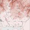
NGR NY 21699 67871
Datum OSGB36 - NGR
Permalink http://canmore.org.uk/site/66994


- Council Dumfries And Galloway
- Parish Annan
- Former Region Dumfries And Galloway
- Former District Annandale And Eskdale
- Former County Dumfries-shire
NY26NW 1 2170 6787.
(NY 2170 6787) Three Piked Stane (NAT) Stone Circle (NR) & St. Marjory's Cross (NR) (Site of)
OS 6" map (1945)
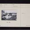
The Three Piked Stane is a large stone about 3 feet long, two feet wide, and about one foot thick, built into a bank a little to the west of Upper Woodhead. It is said to bear three holes, from which it derives its name but the only face visible was blank.
Several stones built into the banks near the place have evidently been removed from the 'Druidical Temple' said to have been on this spot. The 'Three Pikes Stane' is also identified as having formed part of St. Marjory's Cross, a stone in which a wooden cross formerly stood.
Name Book 1858; Statistical Account (OSA) 1792
There are two big granite boulders here, about 11 feet 6 inches apart. Other boulders lie along the parish boundary to the NE. There are no signs of St. Marjory's Cross.
Information from O G S Crawford 25 September 1934
In the corner of a field at NY 2169 6787 are two large rounded boulders. The southernmost is 1.2m long by 0.7m wide, and 0.7m high: the other is 1.1m long by 0.6m wide and 0.7m high. No markings or holes were seen on the boulders and it is impossible to say which stone, if any, is the Three Piked Stone. It is possible that the boulders are the remains of a stone circle as there are several stones nearby and in the hedgerow, but all are much smaller than the two described.
No further information was found regarding St. Marjory's Cross or its site.
Revised at 25".
Visited by OS (WDJ) 28 February 1963
Insufficient evidence to confirm a stone circle.
Visited by OS (JP) 21 February 1973.
Field Visit (6 October 1912)
Stone Circle and St Marjory's Cross (remains of), Woodhead.
On the boundary of the parishes of Dornock and Annan, between two plantations, and about ¼ mile west by south of Woodhead cottage, the OS map marks 'Stone Circle and St Marjory's Cross (remains of)'. These now consist of two granitic boulders about 11 feet 6 inches apart, the largest of which is some 3 feet in height above ground.
RCAHMS 1920, visited 6 October 1912.
OS 6" map, Dumf., 2nd ed, (1900).
Reference
NY26NW 1 2170 6787.
Three Piked Stane. Listed as stone circle (possible) and cross (possible).
RCAHMS 1997.

