
Following the launch of trove.scot in February 2025 we are now planning the retiral of some of our webservices. Canmore will be switched off on 24th June 2025. Information about the closure can be found on the HES website: Retiral of HES web services | Historic Environment Scotland
Loch Mannoch


Stone Circle (Neolithic) - (Bronze Age)
Site Name Loch Mannoch
Classification Stone Circle (Neolithic) - (Bronze Age)
Canmore ID 64182
Site Number NX66SE 2
NGR NX 6628 6143
Datum OSGB36 - NGR
Permalink http://canmore.org.uk/site/64182


- Council Dumfries And Galloway
- Parish Tongland
- Former Region Dumfries And Galloway
- Former District Stewartry
- Former County Kirkcudbrightshire
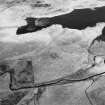
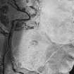
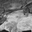
NX66SE 2 6629 6143.
(NX 6629 6143) Stone Circle (NR) (Remains of)
OS 6"map, (1958)
A stone circle on the summit of a slight plateau, composed of ten stones almost entirely sunk beneath the surface, with a large granite block, irregularly four-sided and pointed at one end, measuring 5ft 4ins in length by 2ft 3ins in breadth, lying at the centre, but evidently originally erect.
RCAHMS 1914, visited 1911
This stone circle is generally as described by the RCAHMS.
Revised at 1/2500.
Visited by OS (WDJ) 5 August 1968
Field Visit (7 February 1990)
MacKerlie (1879) describes the site as being a circle of eleven stones with a twelfth one in the centre but this is probably a mistake; the ten surviving stones are quite regularly laid out with no obvious gaps, and all succeeding plans from Coles (1895) onwards show the same layout.
Visited by RCAHMS (CAA) 7 February 1990
Field Visit (5 March 1990)
The stone circle is situated on the leading edge of a terrace immediately above the loch. It measures 6.6m from NW to SE by 6.3m transversely and comprises 10 stones in a circle, protruding c.0.1m above the surface of the peat, together with a prostrate slab in the centre, 1.6m long, which is aligned from NW to SE. It seems likely that the stone hole lies beneath the NW side of the stone. Peat cover in the vicinity is about 0.3m.
Visited by RCAHMS (DCC) 5 March 1990.

