
Pricing Change
New pricing for orders of material from this site will come into place shortly. Charges for supply of digital images, digitisation on demand, prints and licensing will be altered.
Upcoming Maintenance
Please be advised that this website will undergo scheduled maintenance on the following dates:
Thursday, 9 January: 11:00 AM - 3:00 PM
Thursday, 23 January: 11:00 AM - 3:00 PM
Thursday, 30 January: 11:00 AM - 3:00 PM
During these times, some functionality such as image purchasing may be temporarily unavailable. We apologise for any inconvenience this may cause.
Eggerness Castle


Castle (Medieval)(Possible), Promontory Fort (Period Unassigned)
Site Name Eggerness Castle
Classification Castle (Medieval)(Possible), Promontory Fort (Period Unassigned)
Canmore ID 63187
Site Number NX44NE 5
NGR NX 4947 4776
Datum OSGB36 - NGR
Permalink http://canmore.org.uk/site/63187


- Council Dumfries And Galloway
- Parish Sorbie
- Former Region Dumfries And Galloway
- Former District Wigtown
- Former County Wigtownshire
NX44NE 5 4947 4776.
(NX 4944 4775) Eggerness Castle (NR) (Site of)
(NX 4942 4773) Castle Well (NR)
OS 6" map (1957)
According to NSA this is the site of Eggerness Castle (history unknown) with a fine spring well known as Castle Well.
NSA 1845 (E W Davidson and A Forrester); Name Book 1848
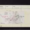
NX 4947 4776. On Castle Head, a rocky promontory, there are the mutilated remains of an Iron Age promontory fort consisting of two ramparts and ditches. The outer ditch is generally intact but the ramparts and inner ditch are very disturbed, particularly in the S where there are a number of modern walls, some of which are now collapsed. The entrance is not certain but may have been just N of the middle of the defences where there are suggestions of a gap.
There is no trace of any building within the fort. A slight issue of water seeps from the place published as Castle Well but this name is not known locally although "Eggerness Castle" is still in use.
Revised at 1/2500.
Visited by OS (JP) 15 December 1970
Note (20 December 2013 - 31 August 2016)
Traditionally identified as Eggerness Castle, and depicted on the 1st edition of the OS 6-inch map with an open rectangle behind an arc of ditch cutting off the approaches to this rock girt promontory from the slopes dropping in from the W, it was identified by John Palmer of the OS in 1973 as the remains of a promontory work defended by two ramparts and ditches. Of these only the outer ditch is complete, and this is shown on the earlier maps about 9m in breadth; its rampart and the inner line are heavily disturbed by the construction of more recent walls, which are themselves largely collapsed. No trace of any other structures could be seen within the interior, and the only evidence of an entrance was a possible gap in the centre of the arc of defences.
Information from An Atlas of Hillforts of Great Britain and Ireland – 31 August 2016. Atlas of Hillforts SC0233

