
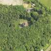
Sorbie Tower


Tower House (Medieval)
Site Name Sorbie Tower
Classification Tower House (Medieval)
Alternative Name(s) Old Place Of Sorbie; Old Tower Plantation
Canmore ID 63139
Site Number NX44NE 1
NGR NX 45089 47025
Datum OSGB36 - NGR
Permalink http://canmore.org.uk/site/63139


- Council Dumfries And Galloway
- Parish Sorbie
- Former Region Dumfries And Galloway
- Former District Wigtown
- Former County Wigtownshire
NX44NE 1 45089 47025
Sorbie Tower [NAT]
OS (GIS) MasterMap, July 2009.
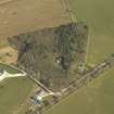
See also NX44NE 43: Field Survey Area, Old Tower Plantation.
For Sorbie motte (adjacent to S), see NX44NE 2.
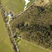
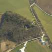
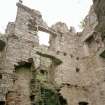
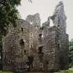
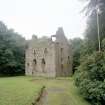
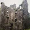
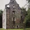
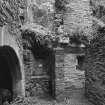
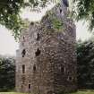
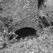
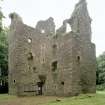
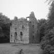
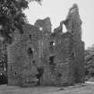
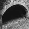
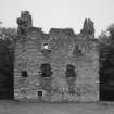
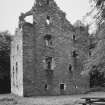
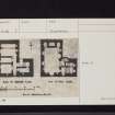
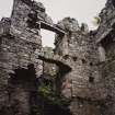
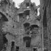
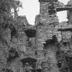
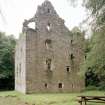
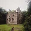
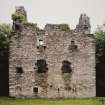
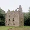
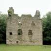
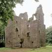
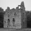
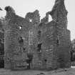
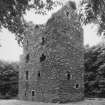
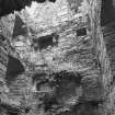
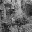
Built towards the end of the 16th century. L-shaped on plan, the main block measuring 40ft 3ins by 24ft externally with a 20ft wide wing projecting 25ft 9ins from it. Though still a very substantial building, it is in poor repair, particularly the E wing of the main block, and part of the vault over the kitchen has collapsed. It was probably also protected by a moat of which perhaps sections can be traced to the E of the tower and elsewhere, and by a barmkin enclosing a courtyard. SE of the tower is a stone-lined well, and there are some small stony mounds to the E.
D MacGibbon and T Ross 1889; RCAHMS 1912; I F MacLeod 1969
Sorbie Tower (name confirmed locally) is generally as described although no trace of a well, moat or barmkin could be found. The small stony mounds in the wood appear to be relatively recent clearance heaps.
Visited by OS August 1970.
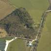
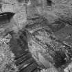
A survey of Sorbie Tower and motte (NX44SE 2) was carried out and a full set of measured drawings has been prepared; lodged with RCAHMS. To the N and E of the tower two deep parallel ditch and bank systems were noted. Beyond these were traces of rig alteration and field dykes. The line of a well cobbled roadway was plotted for some 150m in a NE direction from the courtyard at the entrance to the tower. Between the tower and the ditches were a number of stone scatters, remains of stone structures, a well and some smaller ditches (see also NX44SE 16).
S Wood, C Wood and S Grant 1983
Magnetometry (October 1996)
NX 450 470 A geophysical survey was carried out in October 1996, commencing with an archaeological subsoil evaluation of the site. This evaluation is being used to compose a research strategy for the site, with an objective to open and present it more fully to the visitor.
Traces were indicated of a structure on the top of the motte, a bailey, and other features on the approach to the tower and motte from the NE. Two areas were surveyed using resistivity and magnetometry, with some useful results.
Sponsor: Clan Hannay Society.
P Harrington 1996.
Earth Resistance Survey (October 1996)
NX 450 470 A geophysical survey was carried out in October 1996, commencing with an archaeological subsoil evaluation of the site. This evaluation is being used to compose a research strategy for the site, with an objective to open and present it more fully to the visitor.
Traces were indicated of a structure on the top of the motte, a bailey, and other features on the approach to the tower and motte from the NE. Two areas were surveyed using resistivity and magnetometry, with some useful results.
Sponsor: Clan Hannay Society.
P Harrington 1996.
Note (5 July 2022)
Sorbie Tower was probably built by Alexander Hannay of Sorbie, who held the lands of Sorbie from 1569 to around 1612. The Hannays were an important and influential family in Wigtownshire from at least the 13th century and appear to have held the lands of Sorbie from the mid-15th century. The family's fortunes declined during the late 16th century due to feuds and disputes with powerful neighbours such as the Murrays of Broughton, the Stewarts of Garlies and the Kennedys.
Most of the Sorbie estates were sold in 1626 to Sir Patrick Agnew, and the lands were later granted to the Stewarts of Garlies, who took possession of the Old Place of Sorbie in 1677. The last occupant was Brigadier-General John Stewart, M.P. for Wigtonshire in the British Parliament of 1707, who owned the tower until his death in 1748.
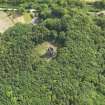
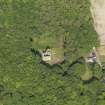
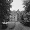
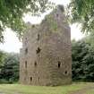
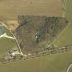
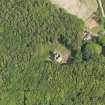
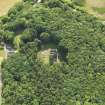
Sorbie Tower, or the Old Place of Sorbie, is a late 16th century tower-house, standing virtually complete to the wall-head. It is located within a plantation on a low rise which originally would have been surrounded by bog and marsh. To the south of the tower is a square mound, the remains of a predecessor motte and bailey castle. The motte has been terraced, presumably at a later date as a garden feature in the later phases of the tower's occupation. The tower is surrounded by a cobbled courtyard.
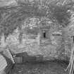
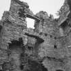
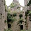
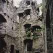
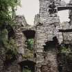
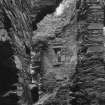
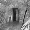
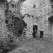
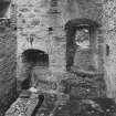
The tower is built to an L-shaped plan; above a vaulted basement there are three storeys with perhaps an attic in the roof space. The masonry is rubble with undressed quoins and simple chamfered sandstone dressings.
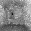
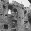
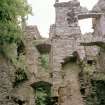
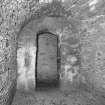
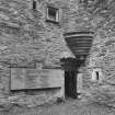
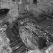
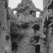
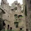
The entrance to the tower is in the re-entrant angle of the wing, which contains a scale-and-platt stair to the first floor. The ground floor has typical late 16th century arrangements with a passageway giving access to cellars and a kitchen which are well lit with a number of unusually large windows for the ground-floor spaces in a tower of this date. The kitchen has a large a fireplace, the arch of which has been rebuilt, and a slop drain.
The first floor of the main block would have contained a well lit hall, and there was a large fireplace, now very ruinous, in the east wall. The lower end of the hall may have been enclosed by a screen, as there is a small fireplace in the south wall. The upper floors would have been reached by a large circular stair corbelled out in the re-entrant angle, although the stair treads have been robbed out. Each of the upper floors of the main block was divided into two unequal chambers with separate access from the stair. The third-floor chambers, which were partly in the roof and lit by dormer windows, are augmented by small studies in roofed turrets at the north-west, north-east and south-west angles. There would have been further accommodation in the wing.
Information from HES 5 July 2022

