
Following the launch of trove.scot in February 2025 we are now planning the retiral of some of our webservices. Canmore will be switched off on 24th June 2025. Information about the closure can be found on the HES website: Retiral of HES web services | Historic Environment Scotland
Castle Feather


Promontory Fort (Period Unassigned), Tower House (Medieval)
Site Name Castle Feather
Classification Promontory Fort (Period Unassigned), Tower House (Medieval)
Alternative Name(s) Burrow Head
Canmore ID 63137
Site Number NX43SW 1
NGR NX 4482 3423
Datum OSGB36 - NGR
Permalink http://canmore.org.uk/site/63137


- Council Dumfries And Galloway
- Parish Whithorn
- Former Region Dumfries And Galloway
- Former District Wigtown
- Former County Wigtownshire
NX43SW 1 4482 3423.
(NX 4482 3423) Castle Feather (NR)
OS 6" map (1957)
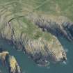
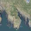
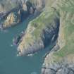
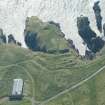
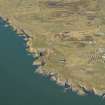
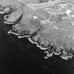
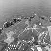
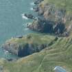
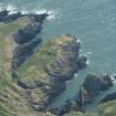
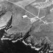
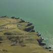
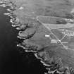
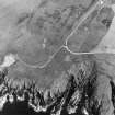
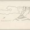
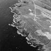
Castle Feather is a two period site, a promontory fort having subsequently been utilised for a medieval castle. The medieval features comprise the internal structures, the largest of which has 4' thick walls and is presumably the tower-house, while the others are ancillary buildings and the revetting of the scarp of the inner ditch is stone. The ramparts and ditches belong to the promontory fort, though they have subsequently been heavily mutilated. These defences seem to have comprised five earthen ramparts and ditches on the N side, and three on the S, but the central area is so disturbed that the relationship of these ramparts to one another is quite uncertain. The circular hollow in the interior, mentioned by the RCAHMS, is a quarry, no doubt contemporary with the castle.
RCAHMS 1912, visited 1911; TS., visited 1955
Generally as described. The multivallate promontory fort measures internally 88.0m NE-SW by 28.0m NW-SE. The probable tower-house foundations measure internally 5.0m by 4.0m. The medieval defensive wall, on the inside of the inner ditch, measures up to 3.7m in height and 2.0m wide.
Resurveyed at 1/2500.
Visited by OS (DWR) 23 January 1973
Field Visit (11 October 1955)
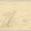
This site was included within the RCAHMS Marginal Land Survey (1950-1962), an unpublished rescue project. Site descriptions, organised by county, are available to view online - see the searchable PDF in 'Digital Items'. These vary from short notes, to lengthy and full descriptions. Contemporary plane-table surveys and inked drawings, where available, can be viewed online in most cases - see 'Digital Images'. The original typecripts, notebooks and drawings can also be viewed in the RCAHMS search room.
Information from RCAHMS (GFG) 19 July 2013.
Note (20 December 2013 - 31 October 2016)
This promontory work has been re-occuppied for the site of a castle, with a stone wall rising vertically from the bottom of the innermost rock cut ditch, which itself measures at least 7.8m in breadth by over 3m in depth and cuts across the neck of the promontory to either side of a central causeway, from the head of a precipitous cleft on the SE to the cliff-edge on the NW. Whether this ditch has been adapted from the innermost defences of the earlier promontory fort is unclear, but along the NW margin of the promontory the stubs of at least four outer ramparts can be seen, each with an external ditch. With the exception of the innermost, which appears to be a counterscarp bank to the castle ditch, all these ramparts are heavily disturbed, to the point in the central sector immediately outside the entrance into the castle that they have been levelled. Where they re-emerge eastwards, swinging round the head of the cleft protecting the SE side of the promontory, only two ramparts and ditches can be seen, both giving the appearance that they are more substantial than any of those visible on the NW. The interior of the castle measures 88m in length from NE to SW by 25m transversely (0.16ha), the area immediately behind the wall being occupied by the footings of three buildings, but if any of the outer lines formed the inner rampart of the promontory fort its interior would have exceeded 0.2ha.
Information from An Atlas of Hillforts of Great Britain and Ireland – 31 October 2016. Atlas of Hillforts SC0232

