
Burrow Head


Promontory Fort (Period Unassigned)
Site Name Burrow Head
Classification Promontory Fort (Period Unassigned)
Canmore ID 63136
Site Number NX43SE 3
NGR NX 4559 3412
Datum OSGB36 - NGR
Permalink http://canmore.org.uk/site/63136


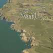
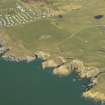


- Council Dumfries And Galloway
- Parish Whithorn
- Former Region Dumfries And Galloway
- Former District Wigtown
- Former County Wigtownshire
NX43SE 3 4559 3412.
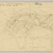
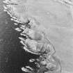
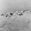
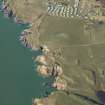
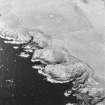
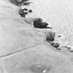
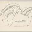
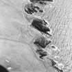
(NX 4559 3412) Another promontory fort adjoins the E side of the fort NX43SE 1. Its principal feature is a ditch, extending in a curve across the neck of a small headland, leaving only a single opening for an entrance, 12' wide, at the E end. The ditch ranges from 35' to 50' in width and measures 6' in depth externally and 13' in depth internally. The rampart, which is separated from the ditch by a gently inclined berm, has been reduced to a low ragged bank about 10' thick whose only distinguishing feature is a slight in-turn at the E end where it flanks the entrance. The interior is 170' long by 30' wide, but has probably been reduced in width by erosion since the fort was built. It is grass-covered and featureless.
It is not possible to determine the chronological relationship between this fort and NX43SE 1 since the junction of their respective ditches is obscured by the causeway.
RCAHMS TS., visited 1955; R W Feachem 1956
Generally as described although the ditch is flanked by a counterscarp which is surmounted by a modern wall.
Resurveyed at 1/2500.
Visited by OS (IA) 24 January 1973
Field Visit (11 October 1955)
This site was included within the RCAHMS Marginal Land Survey (1950-1962), an unpublished rescue project. Site descriptions, organised by county, are available to view online - see the searchable PDF in 'Digital Items'. These vary from short notes, to lengthy and full descriptions. Contemporary plane-table surveys and inked drawings, where available, can be viewed online in most cases - see 'Digital Images'. The original typecripts, notebooks and drawings can also be viewed in the RCAHMS search room.
Information from RCAHMS (GFG) 19 July 2013.
Reference (1957)
This site is noted in the ‘List of monuments discovered during the survey of marginal land (1951-5)’ (RCAHMS 1957, xiv-xviii).
Information from RCAHMS (GFG), 24 October 2012.
Note (20 December 2013 - 22 November 2016)
This promontory work is situated immediately E of Atlas No. 0230, indeed the outermost defence of that fort and the ditch of this enclosure may intersect, though the sequence between them is unknown. The two promontories are separated by a steep-sided gully, which has been exploited to create a ditch cutting off access to the eastern one. Traces of a counterscarp bank can be detected beneath the adjacent field-dyke, but little can be seen of a rampart on the slope that rears up behind this ditch. There is a very clear ditch terminal where a causeway about 3.5m wide has been left for an entrance adjacent to the cliff-edge on the E. The interior has been heavily eroded, forming a narrow finger some 60m in length from the causeway on the NE to its pointed tip on the SW, by a maximum of 23m transversely (0.07ha). The only feature that can be seen within is a ragged bank lying roughly parallel to the ditch. In its present form this bank does not make a particularly convincing rampart, rather it may be the leading edge for the stance of a rectangular building about 13m in length.
Information from An Atlas of Hillforts of Great Britain and Ireland – 22 November 2016. Atlas of Hillforts SC0231

