Drumfern
Stone Circle (Neolithic) - (Bronze Age)
Site Name Drumfern
Classification Stone Circle (Neolithic) - (Bronze Age)
Canmore ID 63017
Site Number NX37SE 10
NGR NX 3999 7099
Datum OSGB36 - NGR
Permalink http://canmore.org.uk/site/63017
- Council Dumfries And Galloway
- Parish Minnigaff
- Former Region Dumfries And Galloway
- Former District Wigtown
- Former County Kirkcudbrightshire
NX37SE 10 3999 7099.
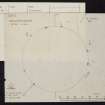
(NX 3999 7099) The remains of a stone circle lie circa 84' ENE of NX37SE 5. Five stones remains in situ, two others are prostrate and a group of boulders marks the site of another. The stones are middle-sized boulders, 2' 8" in maxiumum height, set with their broad faces on the line of the circumference. Adjacent lie a number of similar stones, probably other members moved. (Plan from Prof. A Thom)
RCAHMS 1914, visited 1912
A stone circle as described and planned. The stones, which have a maximum height of 1.0m and are up to 1.0m broad, form a circle 26.0m in diameter.
Surveyed at 1:10 000.
Visited by OS (BS) 6 April 1976


