
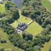
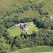
Old Place Of Mochrum


Tower House (Medieval)
Site Name Old Place Of Mochrum
Classification Tower House (Medieval)
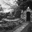
Alternative Name(s) Mochrum Castle Policies; Drumwalt; Old Place Of Mochrum With Walled Garden, Wellhead And Sundial
Canmore ID 62910
Site Number NX35SW 3
NGR NX 30792 54089
Datum OSGB36 - NGR
Permalink http://canmore.org.uk/site/62910


- Council Dumfries And Galloway
- Parish Mochrum
- Former Region Dumfries And Galloway
- Former District Wigtown
- Former County Wigtownshire
NX35SW 3.00 30792 54089
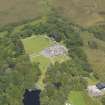
(NX 3080 5409) Old Place of Mochrum (NR)
OS 6" map (1957).
Old Place of Mochrum [NAT]
OS (GIS) MasterMap, August 2009.
NX35SW 3.01 NX 30754 53895 Electricity House and Sawmill
NX35SW 3.02 NX 30747 53971 Bridge and Sluice Gate
NX35SW 3.03 NX 30828 53941 Cart Shed
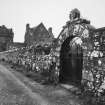
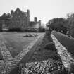
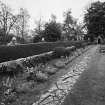
NX35SW 3.04 NX 30774 54129 Walled Garden
NX35SW 3.05 NX 30805 54053 Sundial
NX35SW 3.06 NX 30684 53954 Boathouse (Mochrum Loch)
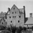
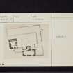
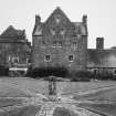
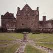
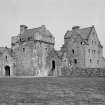
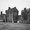
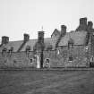
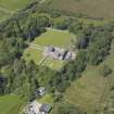
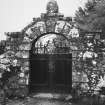
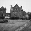
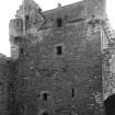
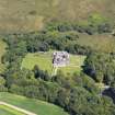
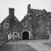
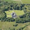
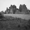
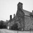
The Old Place of Mochrum, also known as Drumwalt, consisted of two towers, circa 15' apart, linked by a high wall and stood in ruins until 1876 when renovation and extensions after the old style were commenced. The west tower is the older of the two, probably dating from circa 1500. It is a plain rectanguler building four storeys and a garret in height with walls 5 1/2' thick and has been finished with angle-turrets, a capehouse and a parapet walk. The upper portions have been rebuilt, carefully reproducing the old form. The east tower, probably dating from the end of the 16th century, is also rectangular but with walls only 4' thick. It differs from the west tower in having neither angle-turrets nor parapet. The gables and upper floors have been renovated. The entrances to both towers were covered by a pend or archway 7' wide, only the foundation of which survived in 1889. It is probable that the courtyard formed by the modern buildings on the north and east occupies the site of one simply enclosed by high walls.
The property belonged to the Earls of Dunbar and March until circa 1694 when it passed to the Earls of Dumfries. The Marquis of Bute acquired it c1876.
D MacGibbon and T Ross 1889; RCAHMS 1912, visited 1911; N Tranter 1965
This building is outstanding and is as described by the previous authorities.
Visited by OS (BS) 7 July 1976.
Architect: Robert Weir Schultz (restoration)
NMRS REFERENCE:
Extracts from Office Contracts Books, Fee Books - Typescript (R//P109) etc.
(Undated) information in NMRS.
Photographic Survey (1941 - 1953)
Photographic survey of Old Place of Mochrum, Wigtownshire. The photographs are undated but may have been taken by the National Buildings Record Scottish Council between 1941-1953.

