Boreland Mote
Motte (Medieval)
Site Name Boreland Mote
Classification Motte (Medieval)
Canmore ID 62838
Site Number NX35NE 1
NGR NX 3550 5839
Datum OSGB36 - NGR
Permalink http://canmore.org.uk/site/62838
- Council Dumfries And Galloway
- Parish Kirkcowan
- Former Region Dumfries And Galloway
- Former District Wigtown
- Former County Wigtownshire
NX35NE 1 3550 5839.
(NX 3550 5838) Boreland Mote (NR)
OS 6" map (1957)
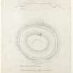
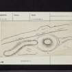
Boreland Mote, a motte, stands 20' above a 20' wide ditch, which is 5'6" deep and has a slight external bank. Its oval summit, which has had its edge somewhat mutilated by sheep, etc, measures 40' N-S by 25' E-W. In its centre is a shallow oval depression, 11'6" x 20'. From the S, a raised bank or roadway, 20' wide, has been formed for about 75 yds, ending at the edge of the ditch, which is shallower in front of it than elsewhere. A similar bank approaches the mound on the opposite side for about 26 yds. Between the end of this approach and the edge of the bank, the ditch seems to be filled or has never been excavated.
RCAHMS 1912, visited 1911; R W Feachem 1956
NX 3550 5839 Boreland Mote is generally as described by the previous authorities. It is 5.5m high and has an oval, tree-covered summit now measuring 8.0m N-S by 7.0m. There is no sign of any depression on this summit. The motte has been constructed at the N end of a low ridge and has what appear as low flat banks running northwards and southwards from its perimeter ditch. There is nothing to suggest, however, that these banks are artificial. The perimeter ditch, which is 6.0m wide and 1.0m deep, survives on all but the E side.
Surveyed at 1:2500.
Visited by OS (BS) 21 April 1976


