
Druchtag Mote Hill


Motte (Medieval)
Site Name Druchtag Mote Hill
Classification Motte (Medieval)
Alternative Name(s) Mote Of Druchtag; Druchtag Motehill; Mochrum Motte
Canmore ID 62746
Site Number NX34NW 5
NGR NX 3495 4665
Datum OSGB36 - NGR
Permalink http://canmore.org.uk/site/62746


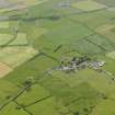
- Council Dumfries And Galloway
- Parish Mochrum
- Former Region Dumfries And Galloway
- Former District Wigtown
- Former County Wigtownshire
NX34NW 5 3495 4665
Not to be confused with Duchtag Castle (NX 3434 4619), for which see NX34NW 6.
(NX 3495 4665) Mote of Druchtag (NR)
OS 6" map (1957)
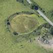
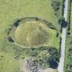
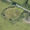
Druchtag Motehill: The earthwork mound of an early medieval castle, with some traces of stone buildings.
S Piggott and W D Simpson 1970
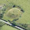
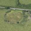
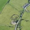
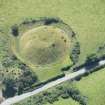
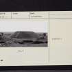
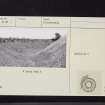
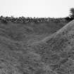
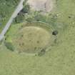
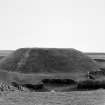
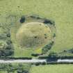
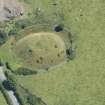
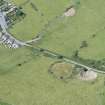
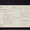
Mote of Druchtag: This motte of the usual truncated cone form, has been erected on a slope. Except towards the E, where it is represented by a terrace on the face of the slope, it is surrounded by a ditch, 25' wide and 6'-8' deep. The flat summit is 66' in diameter. At the E side is an irregular hollow, probably due to excavation, about the sides of which some blocks of stone are exposed. On the W side are two small circular depressions about 18" deep and 7'-8' in diameter. There are no indications of an approach, or of a bailey.
It has no recorded history, but presumably is of circa 12th century date (C A R Radford 1951).
RCAHMS 1912, visited 1911; E W MacKie 1975
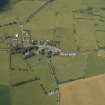
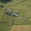
Druchtag Mote Hill (Department of Environment nameplate) is a well-preserved motte built into the top of a shallow ridge. Its mound, which has a 22.0m diameter flat top, stands 6.5m high and is surrounded by a partially silted ditch 10.0m wide and now of 2.0m maximum depth. There is no trace of an outer bank and a 1.5m high field wall follows the top edge of the ditch for most of its perimeter.
On the west side (not east (RCAHMS)) the ground falls steeply away and the ditch is now only represented as a 3.0m wide terrace. The level top has a stony content and although there are a number of minor depressions no traces of any structure are evident.
Surveyed at 1:2500.
Visited by OS (BS) 12 May 1977.
Publication Account (1986)
When they first come on record in the later Middle Ages, the lands of Druchtag formed part of the barony of Mochrum and were held by the McCullochs of Druchtag. Nothing is known, however, about the state of feudal lordship when this castle was thrown up, probably in the later 12th century. The village of Kirk of Mochrum, a short distance to the south, may have originated alongside it.
The motte is as typical as any structure of its kind can be: a steep-sided mound in the 'pudding-shaped' mould, it lacks its timber defences and buildings but is otherwise straight out of the fabric of the Bayeux Tapestry. Except on the roadside bank, the base of the motte is encircled by a deep and wide ditch, the upcast of which formed the mound itself and the low outer rim known as a counters carp bank. The summit area is level and roughly circular on plan, just over 20m in diameter. There is no clear evidence of a bridged approach.
Information from ‘Exploring Scotland’s Heritage: Dumfries and Galloway’, (1986).

