
Following the launch of trove.scot in February 2025 we are now planning the retiral of some of our webservices. Canmore will be switched off on 24th June 2025. Information about the closure can be found on the HES website: Retiral of HES web services | Historic Environment Scotland
Standing Stones Of Glenterrow


Four Poster Stone Circle (Neolithic) - (Bronze Age)
Site Name Standing Stones Of Glenterrow
Classification Four Poster Stone Circle (Neolithic) - (Bronze Age)
Alternative Name(s) Pinwherrie Farm
Canmore ID 61765
Site Number NX16SW 8
NGR NX 14540 62513
NGR Description Centre
Datum OSGB36 - NGR
Permalink http://canmore.org.uk/site/61765


- Council Dumfries And Galloway
- Parish Inch
- Former Region Dumfries And Galloway
- Former District Wigtown
- Former County Wigtownshire
NX16SW 8 1453 6251.
(NX 1453 6250) Standing Stones of Glenterrow (NR).
OS 1:10000 map (1979)
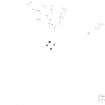
Five boulders 2' to 3' high, four of them set in a rectangle with an outlier to the NE. RCAHMS interpret the rectangular setting as being the remains of a double concentric stone circle. The stones believed to be those of the outer circle are oval in section, measuring 2' 10" and 2' 7" respectively in breadth at base, both upright, 4' apart, and set slightly convergent as if the centre of the circle had been towards the WNW. The other pair of stones, one of which has fallen, are 3' 2" apart at base, and are each 4' 8" distant respectively from the opposite stone of the outer segment. Some 40' to the NE is the fifth stone, similar in appearance and possibly not in situ, but if it is, it cannot have belonged to the same circle as the others. It is not upright.
RCAHMS 1912, visited 1911
This setting of stones, together with its outlier, is as described by the RCAHMS. The purpose of these stones is not clear, but it is doubtful if they are the remains of a double concentric stone circle.
Surveyed at 1:10000 scale.
Visited by OS (JP) 4 May 1976
This four-poster stone setting is situated on a low ridge 200m NW of the public road from New Luce to Castle Kennedy. Trapezoidal on plan, it measures a maximum of 3m by 2.5m, with the tallest stones on the SW and SE (0.6m), and the shortest on the NW (0.4m). There is also a possible outlying stone, a large irregular boulder, 13.5m to the NE.
RCAHMS 1987, visited (SH) August 1985.
Measured Survey (9 August 1985)
RCAHMS surveyed the standing stones of Glenterrow on 9 August 1985 with plane-table and alidade at a scale of 1:100.
Note (26 January 2022)
The location, classification and period of this site have been reviewed and changed from STONE CIRCLE (NEOLITHIC) - (BRONZE AGE).

