
Following the launch of trove.scot in February 2025 we are now planning the retiral of some of our webservices. Canmore will be switched off on 24th June 2025. Information about the closure can be found on the HES website: Retiral of HES web services | Historic Environment Scotland
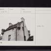
Killumpha Tower


Farmhouse (18th Century), Farmstead (18th Century), Tower (17th Century)
Site Name Killumpha Tower
Classification Farmhouse (18th Century), Farmstead (18th Century), Tower (17th Century)
Canmore ID 61147
Site Number NX14SW 6
NGR NX 11250 40746
Datum OSGB36 - NGR
Permalink http://canmore.org.uk/site/61147


- Council Dumfries And Galloway
- Parish Kirkmaiden
- Former Region Dumfries And Galloway
- Former District Wigtown
- Former County Wigtownshire
NX14SW 6 11250 40746.
(NX 1125 4074). At Killumpha farm is a two-storied tower with angle turrets - ?17th century. Two-storied farmhouse adjoining; modern additions and alterations (see also NX14SW 7).
SDD List, undated
The tower measures externally 5.5m E-W by c.5.4m transversely, and no positive dating evidence is visible although it is similar in exterior design to NX14SW 12.
Visited by OS (DWR) 25 January 1972
NX14SW 6 11250 40746
Killumpha Tower. See NMRS Archaeology Notes for brief architectural history.

