
Tor Of Craigoch


Fort (Prehistoric)
Site Name Tor Of Craigoch
Classification Fort (Prehistoric)
Canmore ID 60830
Site Number NX06SW 1
NGR NX 00847 64643
NGR Description Centre
Datum OSGB36 - NGR
Permalink http://canmore.org.uk/site/60830


- Council Dumfries And Galloway
- Parish Leswalt
- Former Region Dumfries And Galloway
- Former District Wigtown
- Former County Wigtownshire
NX06SW 1 0085 6464.
(NX 0085 6464) Tor of Craigoch (NAT)
Fort (NR)
OS 1:10000 map (1978).
For Sir Andrew Agnew Monument (within the fort interior), see NX06SW 62.
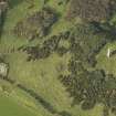
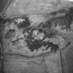
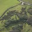
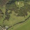
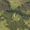
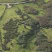
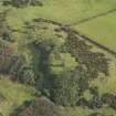
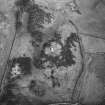
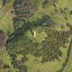
A hill-fort occupying the summit of a hill from the centre of which rises the monument (NX06SW 62) to Sir Andrew Agnew of Lochnaw.
The summit is a flat-topped rock rising steeply on the north and east and by an easier gradient on the west and south. On these two sides the position has been defended by a trench and mound each some 20' wide and the latter now only some 2' in height above the bottom of the trench, but slightly higher where the ground falls away on the outside. Beyond the mound there appears to be a level terrace some 15' wide.
On the south side other banks are visible, possibly connected with old enclosures of later date. The interior of the fort measures about 170' in diameter. The defences are much obscured with shrubs and bushes.
RCAHMS 1912; R W Feachem 1956
The hill has been cleared of shrubs and bushes and it can now be seen that on the south and west sides, where there is only a slight slope, there were four earth and stone ramparts, three of which are now scarps. The remaining sides, apart from the NW where steep natural slopes and a rock face afford protection, were defended by three ramparts, now scarps.
A break in the NE, where a modern track cuts through the ramparts, is almost certainly the original entrance. The banks to the south and east are later field banks.
The name Tor of Craigoch is not in local use.
Resurveyed at 1/2500.
Visited by OS (RD) 19 February 1968
This fort is situated on a small steep-sided hill known as the Tor of Craigoch, about 1km NW of Leswalt. The interior measures about 50m from NE to SW by 38m transversely, but the defences are almost totally obscured by dense thickets of gorse, brambles and rhodedendrons. Traces of two ramparts reduced to stony scarps about 0.6m in maximum height are visible on the S and NE and earlier reports (RCAHMS Survey of Marginal Lands; OS Field Report) record two additional ramparts on the SW. The inner of the two outer ramparts extends round the E, but the portion of it visible on the NE appears to be a natural terrace. The position of the entrance is uncertain, although a gap in the defences has been noted on the NE (OS Field Report). A monument to Sir Andrew Agnew stands at the centre of the interior.
The cup-marks noted on some of the rock surfaces in the interior (Mann 1923) are natural features.
RCAHMS 1912; RCAHMS Survey of Marginal Lands; RCAHMS 1985, visited (SH) October 1984.
Field Visit (8 July 1953)
This site was included within the RCAHMS Marginal Land Survey (1950-1962), an unpublished rescue project. Site descriptions, organised by county, are available to view online - see the searchable PDF in 'Digital Items'. These vary from short notes, to lengthy and full descriptions. Contemporary plane-table surveys and inked drawings, where available, can be viewed online in most cases - see 'Digital Images'. The original typecripts, notebooks and drawings can also be viewed in the RCAHMS search room.
Information from RCAHMS (GFG) 19 July 2013.
Note (20 December 2013 - 31 August 2016)
Situated on a small steep-sided hillock forming a local summit, this fort is oval on plan, measuring about 50m from NE to SW by 38m transversely within at least three ramparts, though these are largely reduced to stony scarps and currently can only be seen in the S quarter. Elsewhere the defences are blanketed in thickets of gorse and rhododendrons, which also cover the possible entrance on the NE noted in 1968 by OS surveyors, and the steep outcrops that afforded protection on the NW.
Information from An Atlas of Hillforts of Great Britain and Ireland – 31 August 2016. Atlas of Hillforts SC0189
Note (16 February 2022)
The location, classification and period of this site have been reviewed and changed from FORT (PERIOD UNASSIGNED).

