
Pricing Change
New pricing for orders of material from this site will come into place shortly. Charges for supply of digital images, digitisation on demand, prints and licensing will be altered.
Dunskey Castle


Tower House (Medieval)
Site Name Dunskey Castle
Classification Tower House (Medieval)
Canmore ID 60632
Site Number NX05SW 3
NGR NX 00368 53385
NGR Description Centre
Datum OSGB36 - NGR
Permalink http://canmore.org.uk/site/60632


- Council Dumfries And Galloway
- Parish Portpatrick
- Former Region Dumfries And Galloway
- Former District Wigtown
- Former County Wigtownshire
NX05SW 3 00379 53391
(NX 0037 5339) Dunskey Castle (NR) (Remains of)
OS 6" map (1957)
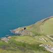
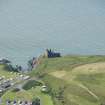
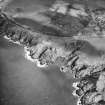
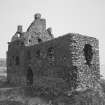
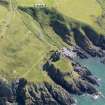
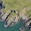
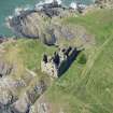
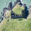
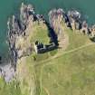
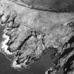
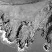
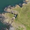
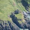
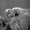
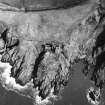
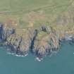
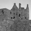
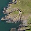
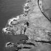
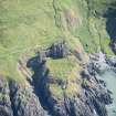
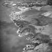
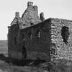
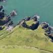
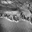
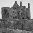
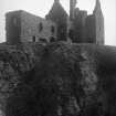
Dunskey Castle occupies a promontory, probably fortified from the earliest times, jutting out into the sea and partly cut off from the mainland by a deep ditch which may be partly natural (R C Reid 1939). Behind this, the walls of the castle are built right across the rock to the cliff edge on either side. It is L-shaped on plan, with 5' thick walls, and is now a rough roofless shell. At the cliff's W edge, there is the foundation of a stone building c.23' square, probably the remains of a watch tower overlooking the sea. There is also a fragment of walling running W of the SW angle of the main building, which would no doubt be part of an annexe.
There appears to have been a castle of Dunskey from very early times, though the present building probably dates to the early 16th century, when the preceding castle was burnt. Symson describes the castle as wholly ruinous, in 1684.
W Macfarlane 1908; RCAHMS 1912, visited 1911.
The remains of this castle are generally as described by RCAHMS except that the "watch tower" is at the east edge of the cliffs. A grassy scarp, 1.0m high running NW across the promontory from the SW corner of the "watch tower" probably indicates the course of a cross-wall.
Revised at 1/2500.
Visited by OS (WDJ) 1 September 1970
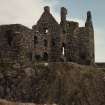
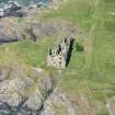
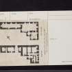
Dunskey Castle, an L-plan tower-house with a stair-tower in the re- entrant angle and a gallery-wing on the NE, stands on a sheer-sided coastal promontory, which is separated from the mainland by a substantial rock-cut ditch (15m wide and 2.5m deep). The tower-house has three principal storeys and measures 30m by 14.3m overall; traces of an adjoining range at the S angle probably included a bakehouse. The promontory (36.5m by 30m) is enclosed by a wall-face (up to 3.8m high ), and on the SW there are the probable remains of a watch-tower.
The tower-house dates to the 16th century and may occupy the site of an earlier castle which is on record in the 14th century.
F Grose 1789-91; NSA 1845; W M'llwraith 1875; G Chalmers 1887-1902; D MacGibbon and T Ross 1887-92; A Agnew 1893; P H M'Kerlie 1906; W Macfarlane 1906-8; RCAHMS 1912; R C Reid 1938; H Dixon 1977; RCAHMS 1985, visited September 1984.
Publication Account (1986)
Perched on a sea cliff, the ruins of this castle occupy the most spectacular coastal setting of any in southwest Scotland. It is a substantial ruin too, presenting a 30.2m-long landward front on the edge of a 15m wide rock-cut ditch. Entry is through an arched gateway in this wall which was originally secured with a sliding drawbar. The promontory on which the castle stands is enclosed within the remains of a circuit-wall; vestiges of a watch-tower lie at the seaward extremity, and foundations of a building, probably including a kitchen, adjoin the south angle of the tower.
The ditch and parts of the enclosure may have formed part of an earlier castle of the Adair family; a castle has been on record since the 14th century, but some time before 1503 it was invested and burnt by the fearsome McCullochs of Myrton and Cardoness. The nucleus of the tower was built early in the 16th century by William Adair of Kinhilt (d. 1513), probable builder also ofStranraer Castle (no. 15). It was later added to and remodelled, the most likely patron for this work being Viscount Montgomery, laird of Dunskey from 1608 until his death in 1636. After his acquisition of the estate in 1648 the Reverend James Blair moved to Killantringan, and already by 1684 this castle was 'wholly ruinous'.
The main block is a sizeable L-plan tower with a later long gallery range to the north-west. The arrangement of rooms follows the usual pattern: vaulted cellars on the ground floor, main public rooms on the first floor, and private chambers on the upper floors. On the first floor, the great hall takes up the whole of the main block, and leads through to the gallery. On the ground floor, the layout around the entrance has been complicated by the later insertion of a large scale-andplatt (straight-flighted) staircase. Previously, the main stair ascended the turret in the re-entrant angle, while the wing may have contained the original kitchen before it was out-housed. Curiously, the water-supply, a well-chamber beneath the east wall, appears to have been accessible only from the outside. The northernmost cellar in the main building was designed for access only from the courtyard, not from within, possibly for stabling. Two dark unlit chambers on the ground floor suggest a more sinister purpose; every good castle should have at least one really unpleasant prison-cell!
Information from ‘Exploring Scotland’s Heritage: Dumfries and Galloway’, (1986).
Note (2 December 2021)
The location, classification and period of this site have been reviewed.
Note (5 July 2022)
The castle was the seat of the Adairs of Kinhilt and the earliest reference to a castle at Dunskey is from 1330. However, the earliest parts of the present building probably date to the first quarter of the 16th century, after its predecessor was burnt by the McCullochs of Myrton and Cardoness. The scale-and-platt stair and the gallery wing may have been part of the alterations and additions traditionally said to be made by Hugh, first Viscount Montgomery of the Great Ardes who was laird of Dunskey from 1608. Symson describes the castle as wholly ruinous in 1684.
Dunskey Castle stands on a sheer-sided coastal promontory jutting into the Irish Sea. The castle, which dates to the late 16th century, appears to contain earlier walling and may occupy the site of predecessor on record in the 14th century. It is separated from the mainland by a substantial rock-cut ditch, perhaps a feature of the early castle, and is approached via a causeway.
The main structure of the castle is an L-plan tower house with an additional block in the re-entrant angle containing the stair from first floor level. It has three principal storeys with ground floor cellarage and a broad scale-and-platt stair to the first floor. This latter stair is a insertion and possibly occupies the site of the original kitchen.
The main block contains the hall at first floor and above there are two chambers each with a fireplace. The wing rises higher than the main block and contains one room on each of the upper floors, each with a fireplace. The upper rooms are accessed by a broad circular stair in the re-entrant angle. Attached to the north flank of the tower is a long and narrow three storey wing, the east wall of which incorporates the earlier courtyard wall and arched gateway of the castle. The first floor of this building appears to have been one long room forming a gallery. There are traces of other buildings along the cliff edge.
J Gifford 1996; D MacGibbon and T Ross 1887; RCAHMS 1912; G Stell 1996
Information from the HES Castle Conservation Register, 5 July 2022

