
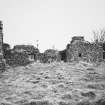
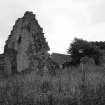
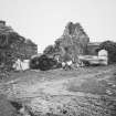
Balsarroch House


Lairds House (17th Century)
Site Name Balsarroch House
Classification Lairds House (17th Century)
Canmore ID 60358
Site Number NW96NE 21
NGR NW 99355 69133
Datum OSGB36 - NGR
Permalink http://canmore.org.uk/site/60358


- Council Dumfries And Galloway
- Parish Kirkcolm
- Former Region Dumfries And Galloway
- Former District Wigtown
- Former County Wigtownshire
NW96NE 21.00 99355 69133
NW96NE 21.00 9935 6913 Sundial
NW96NE 21.00 99398 69139 Walled Garden
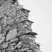
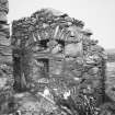
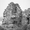
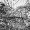
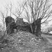
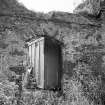
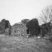
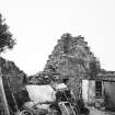
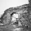
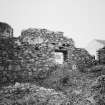
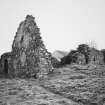
The ruins of Balsarroch, a laird's house of the late 17th century, stand 484m SSE of Cairnbowie farmhouse. The dwelling forms the W range of a courtyard and comprises a two-storey building with crow-stepped gables (that on the N surviving) measuring 16.1m by 4.8m within clay-bonded walls 0.8m thick and up to 4.2m high. The N wall of the courtyard (17.2m long) incorporates an arched opening and on the E there are the remains of a second building.
Retours 1811-1816; Thomson 1826; Register House Plan 4650; Name Book; A Agnew 1893; P H M'Kerlie 1906;C H Dick 1914; RCAHMS 1985, visited August 1984; SRO (RHP) 4650

