
Pricing Change
New pricing for orders of material from this site will come into place shortly. Charges for supply of digital images, digitisation on demand, prints and licensing will be altered.
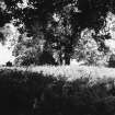
Cranshaws, Old Parish Church And Churchyard


Burial Ground (Medieval), Church (Medieval), Inscribed Stone (Period Unknown)
Site Name Cranshaws, Old Parish Church And Churchyard
Classification Burial Ground (Medieval), Church (Medieval), Inscribed Stone (Period Unknown)
Alternative Name(s) Cranshaws House, Church And Burial Ground
Canmore ID 57528
Site Number NT66SE 6
NGR NT 68380 61678
NGR Description Centre
Datum OSGB36 - NGR
Permalink http://canmore.org.uk/site/57528


- Council Scottish Borders, The
- Parish Cranshaws
- Former Region Borders
- Former District Berwickshire
- Former County Berwickshire
NT66SE 6 68360 61676
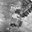
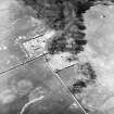
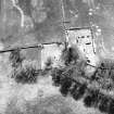
(NT 68360 61676) Cranshaws Old Church (NR) (Remains of)
OS 6" map (1957).
For (successor and present) Cranshaws Parish Church, see NT66SE 18.00 69231 61843.
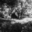
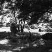
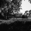
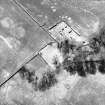
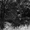
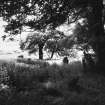
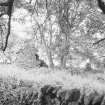
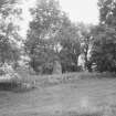
This church, dedicated, or at least containing an altar, to St Ninian, is mentioned in 1296 but it undoubtedly existed long before that, according to Robson. The remaining fragment of the east wall, 2 1/2 ft thick, with foundations of other walls, indicates internal dimensions of 61ft by 14ft.
Excavations in 1889 revealed two doors in the south wall a feature of early churches, and a wall dividing the west end, probably built to form a vestry after the Reformation.
J Robson 1896; J Ferguson 1892
A portion of the east wall, 3.0m high, is standing in good condition: it is of rubble masonry. In addition the foundations of the building are traceable all round, measuring 19.5m by 5.6m externally. A plantation boundary dyke has been built across the NW corner.
Visited by OS (JFC) 16 December 1954
OS (JFC) confirmed.
Visited by OS (EGC) 27 April 1966.
Scheduled as 'Cranshaws House, church and burial ground 150m SE of...'
Information from Historic Scotland, scheduling document dated 20 February 2009.
Field Visit (9 October 1908)
107. Cranshaws Old Church.
The ruins of this church are situated about 220 yards south-south-west of Cranshaws Tower. Only a portion of the east wall remains to a height of about 12 feet, and it presents no features of interest.
RCAHMS 1915, visited 9th October 1908.
OS Map: Ber., ix. NE.
Note (20 December 2019)
The location, classification and period of this site have been reviewed.
Sbc Note
Visibility: This is an upstanding earthwork or monument.
Information from Scottish Borders Council

