
Following the launch of trove.scot in February 2025 we are now planning the retiral of some of our webservices. Canmore will be switched off on 24th June 2025. Information about the closure can be found on the HES website: Retiral of HES web services | Historic Environment Scotland
Yadlee


Stone Circle (Prehistoric)
Site Name Yadlee
Classification Stone Circle (Prehistoric)
Alternative Name(s) Zadlee
Canmore ID 57472
Site Number NT66NE 3
NGR NT 65400 67320
NGR Description Centre
Datum OSGB36 - NGR
Permalink http://canmore.org.uk/site/57472


- Council Scottish Borders, The
- Parish Spott (Berwickshire)
- Former Region Borders
- Former District Berwickshire
- Former County East Lothian
NT66NE 3 6540 6732.
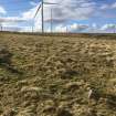
(Area: NT 654 673) A small stone circle 27ft in diameter and comprising seven small stones, all but one still earthfast. The circle lies about 300 yards south by east of Yadlee, at an elevation of about 950ft. The stones, set on edge or on end, measure from 10 to 16 ins across and 8 ins in maximum height. The prostrate stone measures 22 ins by 13 ins. The interior of the circle is on the same level as the surrounding ground and numerous stones are met with on probing. It has not been excavated.
R W Feachem 1963; RCAHMS 1924, visited 1913
A small stone circle, as described above, located at NT 6540 6732. Purpose uncertain.
Surveyed at 1/2500.
Visited by OS (WDJ) 18 April 1966
This stone circle is situated on level though undulating moorland in an area of heather or pasture. Its condition is unchanged.
On plan, the stones describe an oval measuring overall 9.0m E-W by 8.0m N-S. The significance of four earthfast stones outside the northern arc and a random group of five others about 10.0m west of the circle is uncertain, but they do not appear to have formed part of a larger or more complex monument.
Surveyed at 1/10,000.
Visited by OS (JRL) 10 May 1979
Field Visit (1 July 1913)
On the gentle slope of Stonefold Rig on the eastern side of Spartleton Edge, some 300 yards south by east of Zadlee and at an elevation of about 950 feet above sea-level, is a circle of seven small stones, measuring from 10 inches to 16 inches across, set on edge or on end, except one which is now flat (fig. 157 [plan]) . None is more than 8 inches above ground. The flat stone is the largest and measures 22 inches in length by 13 inches in breadth.The circle, which has a diameter of 27 feet, seems complete, except on the northern arc, where there may have been one stone more. The interior of the circle is on the same level as the surroundings, and numerous stones are met with on probing.
RCAHMS 1924, visited 1 July 1913.
Field Visit (12 February 2013 - 12 February 2014)
A measured survey and GIS based landscape study was undertaken in 2013 by students from Edinburgh University under the supervision of Connolly Heritage Consultancy. The survey identified a total of 9 stones within the circle, with a further 17 stones scattered mostly to the south and west, some of which may have keyed alignments. The study suggested alignements with other features in the landscape on the Spring Equinox (Witches Cairn and Rook Law Cairn) and Winter Solstice (Spartleton Cairn).
Source: Connolly Heritage Consultancy
OASIS ID: connolly1-145684
Sbc Note (15 April 2016)
Visibility: Standing structure or monument.
Information from Scottish Borders Council
Field Visit (4 March 2020)
The location, classification and period of this site have been reviewed.

