
Harelaw


Earthwork (Period Unknown)
Site Name Harelaw
Classification Earthwork (Period Unknown)
Alternative Name(s) Harelaw Moor
Canmore ID 57289
Site Number NT64NE 2
NGR NT 6644 4834
Datum OSGB36 - NGR
Permalink http://canmore.org.uk/site/57289


- Council Scottish Borders, The
- Parish Westruther
- Former Region Borders
- Former District Berwickshire
- Former County Berwickshire
NT64NE 2 6644 4834.
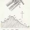
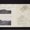
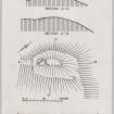
(NT 6644 4834) Fort, Harelaw: This fort is situated on the right bank of the Blackadder, at an elevation of some 640ft OD. It comprises an oval enclosure measuring some 141ft by 71ft within a single rampart, accompanied by an internal ditch. The entrance is in the NE. There are two or three slight indications of hut circles in the interior.
RCAHMS 1915, visited 1912.
This earthwork occupies a natural gravel knoll which has been artificially scarped; the earthen rampart noted by the RCAHMS rises to a maximum height of 0.5m on the NW, but is of negligible height on the SE where the much deeper natural valley offers a good defence. The rampart is about 2.5m wide at base. The internal elevated knoll is of a maximum height of 4m, and has two circular depressions, 3.5m in diameter.
Visited by OS(JFC) 25 January 1955.
Generally as described above. The central knoll has a fairly flat top and seems to have suffered slightly from quarrying at its SW end. There are no indications of hut circles, and the depressions mentioned in the previous field report are not suggestive of such, and are possibly the results of excavations.
Surveyed at 1:2500.
Visited by OS(RDL) 21 August 1963.
(NT 6644 4834) Earthwork (NR)
OS 25"map, (1965).
This earthwork is as described. Its date and purpose are not clear; the enclosed sub-oval summit appears to be too small for a motte. A number of the previously noted features, eg the alleged hut circles, are probably the result of recent gravel extraction.
Visited by OS(MJF) 26 June 1979
As described. Listed among 'Miscellaneous Earthworks and Enclosures'.
RCAHMS 1980, visited September 1979.
Field Visit (November 1912)
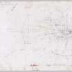
288. Fort, Harelaw.
This fort (fig. 152 [DP 229126]), which is situated on the right bank of the Blackadder where the stream makes a sharp ·bend some 600 yards to the westward of Hallyburton steading, at an elevation of some 640 feet above sea-level and of 50 feet above the stream, occupies the north-east end of a narrow gravelly ridge from which the ground falls away sharply on bo.th sides. It has been an oval enceinte measuring interiorly some 141 feet by 71 feet, surrounded by a single rampart with a trench on the inside. The entrance has been at the north-east end to which a track leads along the slope. In the interior there are two or three slight indications of hut circles.
See Ber. Nat. Club, 1885-86, p. 70.
RCAHMS 1915, visited November 1912.
OS Map: Ber., xxi. NW. (unnoted).
Field Visit (14 August 1952)
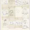
This site was included within the RCAHMS Marginal Land Survey (1950-1962), an unpublished rescue project. Site descriptions, organised by county, are available to view online - see the searchable PDF in 'Digital Items'. These vary from short notes, to lengthy and full descriptions. Contemporary plane-table surveys and inked drawings, where available, can be viewed online in most cases - see 'Digital Images'. The original typecripts, notebooks and drawings can also be viewed in the RCAHMS search room.
Information from RCAHMS (GFG) 19 July 2013.
Sbc Note
Visibility: This is an upstanding earthwork or monument.
Information from Scottish Borders Council

