
Grizzlefield, West Rings


Fort (Prehistoric)
Site Name Grizzlefield, West Rings
Classification Fort (Prehistoric)
Canmore ID 55944
Site Number NT54SE 7
NGR NT 5883 4012
Datum OSGB36 - NGR
Permalink http://canmore.org.uk/site/55944


- Council Scottish Borders, The
- Parish Earlston
- Former Region Borders
- Former District Ettrick And Lauderdale
- Former County Berwickshire
NT54SE 7 5883 4012
(NT 5882 4011) Earthwork (NR) (site of)
OS 6" map (1968).
Not to be confused with East Rings fort (NT 5921 4015), for which see NT54SE 6.
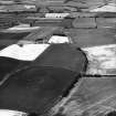
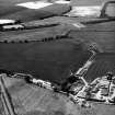
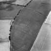
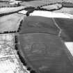
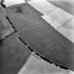
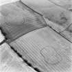
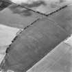
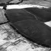
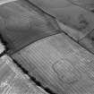
Fort, Grizzlefield 'West Rings': The remains of this oval earthwork are situated at the W end of a ridge at an elevation of some 580ft OD. It has measured some 357ft by 216ft within a single earthen rampart and ditch, both much obliterated by cultivation.
J Tait 1885; RCAHMS 1915, visited 1911.
There is no trace of this earthwork in a ploughed field; it would appear to have been of a non-defensive character.
Visited by OS (JD), 20 May 1955
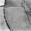
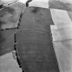
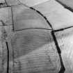
No trace of this enclosure was seen in an arable field. Sited to NT 5882 4011 from air photographs (RAF 106G/UK765: 3426-7, flown 1945).
Visited by OS (WDJ), 10 October 1962.
Also photographed by CUCAP. Visible on RCAHMS air photographs, flown in 1980 (listed as a fort).
Photographed by the RCAHMS in 1980, 1981, 1983, 1989, 1990, 1993 and 1996.
(Undated) information in NMRS.
Field Visit (May 1911)
133. Fort, Grizzlefield ‘West Rings’.
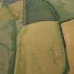
Situated some 400 yards north-east of Grizziefield steading, at the west end of a ridge and some 580 feet above sea-level, are the remains of an oval earthwork (fig. 73 [DP 229122]) which has measured interiorly some 357 feet by 216 feet. It has been surrounded by a single earthen rampart and trench, both much obliterated by cultivation.
RCAHMS 1915, visited May 1911.
O.S.M , Ber., xxvi. SE. (unnoted).
Aerial Photographic Transcription (7 September 1993 - 19 April 1994)
An aerial transcription was produced from oblique aerial photographs. Information from Historic Environment Scotland (BM) 31 March 2017.
Note (18 January 2016 - 10 August 2016)
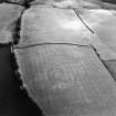
This fort is situated on the W end of a low ridge and is the western of two standing no more than 250m apart to the ENE of Grizzelfield (see Atlas No.4005). First noted on the Map of the County of Berwick surveyed by Andrew and Mostyn Armstrong in 1771, it was ploughed down in the first half of the 19th century, but cropmarks have revealed its overall plan, and the remains of the inner rampart and ditch was still visible round most of the circuit when James Hewat Craw drew up a plan in 1911 (RCAHMS 1915, 76, no.134, fig 74); indeed, surviving traces of the rampart have been revealed by aerial photography in oblique evening light. Sub-oval in overall plan, with a distinct waist midway along its N and S sides, the cropmarks reveal that the defences represent two periods of construction, in which an originally sub circular enclosure about 60m in diameter (0.28ha) within a single rampart and ditch was extended westwards from the waist to form an enclosure measuring internally about 100m from E to W by 60m transversely (0.52ha); traces of the arc of the earlier ditch can be seen on the S side of the interior. In this second phase the ditch was about 6m broad and was accompanied by a much slighter ditch generally set about 5m outside its line, but not reflecting the 'waist', and thus indicating that it is probably an addition. On the N the shadow photographs suggest that a rampart stood between them, and this may well have been the case around the entire circuit. Entrances are visible in both ends, though they are not centrally placed and lie towards the S side, and the one on the E, where the terminals of the ditch are slightly staggered to either side, evidently also served the earlier enclosure. Apart from the earlier ditch, the only feature in the interior is what may be no more than a large oval pit.
Information from An Atlas of Hillforts of Great Britain and Ireland – 10 August 2016. Atlas of Hillforts SC4006
Sbc Note
Visibility: This site is visible as a cropmark.
Information from Scottish Borders Council

