
Hassendean Bank


Fort (Period Unassigned)
Site Name Hassendean Bank
Classification Fort (Period Unassigned)
Canmore ID 55220
Site Number NT51NE 31
NGR NT 5568 1960
Datum OSGB36 - NGR
Permalink http://canmore.org.uk/site/55220


- Council Scottish Borders, The
- Parish Minto
- Former Region Borders
- Former District Roxburgh
- Former County Roxburghshire
NT51NE 31 5568 1960
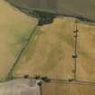
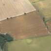
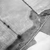
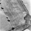
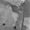
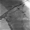
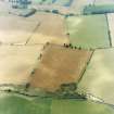
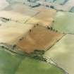
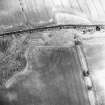
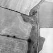
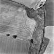
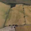
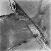
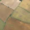
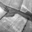
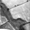
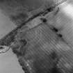
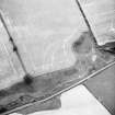
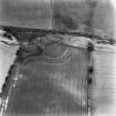
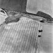
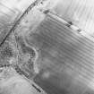
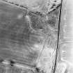
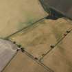
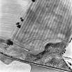
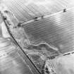
The cropmarks of a fort have been revealed by oblique aerial photography 700m NW of Hassendean Bank farmsteading. It has three outer ditches, each situated about 10m apart and an internal diameter of about 90m. The cropmarks of two settlements have been recorded about 400m to the SW (NT51NE 23 and NT51NE 36 ).
Information from RCAHMS (KJ) 14 July 1999.
Note (17 August 2015 - 18 May 2016)
Cropmarks have revealed a fort occupying a promontory formed on the S side of the shallow gully of the Grinding Burn. Three concentric ditches can be seen on the photographs at intervals of 5m, forming a belt some 26m deep barring access from the S, but elsewhere on the NE and NW there is little more than a low escarpment around the margin of the promontory. The interior measures about 70m from E to W immediately to the rear of the defences by 45m transversely, and allowing for the presence of an inner rampart extends to about 0.2ha. The innermost ditch is about 6m in breadth, while the middle and outer ditches are in the order of 4m, the cropmarks apparently springing in an arc from the lip of the gully on the W but petering out at the edge of the field on the E, possibly indicating the position of the entrance approaching along the NE margin of the promontory on the ESE. Some of the photographs show traces of a narrow feature between the middle and outer ditches, but while those on the E are evidently a field drain, those on the W possibly indicate the presence of a palisade trench. The interior is featureless.
Information from An Atlas of Hillforts of Great Britain and Ireland – 18 May 2016. Atlas of Hillforts SC3287
Sbc Note
Visibility: This site is visible as a cropmark.
Information from Scottish Borders Council

