 |
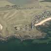
On-line Digital Images |
DP 008983 |
RCAHMS Aerial Photography Digital |
General oblique aerial view centred on the chapel and houses, taken from the S. |
12/7/2005 |
Item Level |
|
|
Photographs and Off-line Digital Images |
H 87696 CS |
RCAHMS Aerial Photography |
General oblique aerial view centred on the remains of the chapel with the village adjacent, taken from the S. |
1/10/1998 |
Item Level |
|
|
Photographs and Off-line Digital Images |
H 87698 CS |
RCAHMS Aerial Photography |
General oblique aerial view centred on the remains of the chapel with the village adjacent, taken from the SE. |
1/10/1998 |
Item Level |
|
|
Photographs and Off-line Digital Images |
H 87697 CS |
RCAHMS Aerial Photography |
Oblique aerial view centred on the remains of the chapel, taken from the NE. |
1/10/1998 |
Item Level |
|
|
Photographs and Off-line Digital Images |
H 87699 CS |
RCAHMS Aerial Photography |
Oblique aerial view centred on the remains of the chapel, taken from the E. |
1/10/1998 |
Item Level |
|
 |
On-line Digital Images |
SC 2448616 |
Records of the Ordnance Survey, Southampton, Hampshire, England |
Earlsferry, Earlsferry Point, Earlsferry Chapel, NT49NE 3, Ordnance Survey index card, Recto |
1958 |
Item Level |
|
 |
On-line Digital Images |
SC 2448617 |
Records of the Ordnance Survey, Southampton, Hampshire, England |
Earlsferry, Earlsferry Point, Earlsferry Chapel, NT49NE 3, Ordnance Survey index card, page number 1, Recto |
1958 |
Item Level |
|
 |
On-line Digital Images |
SC 2448618 |
Records of the Ordnance Survey, Southampton, Hampshire, England |
Earlsferry, Earlsferry Point, Earlsferry Chapel, NT49NE 3, Ordnance Survey index card, page number 2, Verso |
1958 |
Item Level |
|
 |
On-line Digital Images |
SC 2448619 |
Records of the Ordnance Survey, Southampton, Hampshire, England |
Earlsferry, Earlsferry Point, Earlsferry Chapel, NT49NE 3, Ordnance Survey index card, Recto |
1958 |
Item Level |
|
|
Photographs and Off-line Digital Images |
BP 66/2 |
Historic Scotland Archive Project |
Survey photographs: Kincraig Point with trackway at Shell Bay; Chapel remains at Elie; Lower Largo Cardy networks; Largo Bay fish traps, salmon stakes and glider posts; St Ford fishing hut; East Wemyss gasworks cave (film fogged). |
1/1996 |
Batch Level |
|
|
Manuscripts |
MS 2307/2 |
Historic Scotland Archive Project |
Survey archive: Site record sheets from Coastal Assessment Survey for Historic Scotland, Kincardine to Fifeness.
Parcels 8 (MS 2307/2/8), 17 (MS 2307/2/17) and 18 (MS 2307/2/18) not included with archive. |
4/1996 |
Batch Level |
|
|
All Other |
551 359/461/2 PO |
General Collection |
Churches |
|
Sub-Group Level |
|
|
All Other |
551 166/1/1 |
Records of the Ordnance Survey, Southampton, Hampshire, England |
Archaeological site card index ('495' cards) |
1947 |
Sub-Group Level |
|
|
All Other |
551 227/35 |
Records of SUAT Ltd, archaeologists, Perth, Perth and Kinross, Scotland |
Archives from a survey of medieval hospital sites in Scotland |
1997 |
Group Level |
|


