
Torwoodlee


Cultivation Terrace(S) (Period Unassigned)
Site Name Torwoodlee
Classification Cultivation Terrace(S) (Period Unassigned)
Canmore ID 54344
Site Number NT43NE 11
NGR NT 4660 3830
Datum OSGB36 - NGR
Permalink http://canmore.org.uk/site/54344


- Council Scottish Borders, The
- Parish Caddonfoot
- Former Region Borders
- Former District Ettrick And Lauderdale
- Former County Selkirkshire
NT43NE 11 4660 3830.
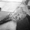
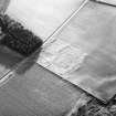
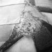
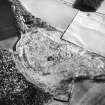
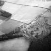
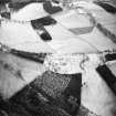
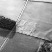
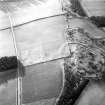
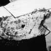
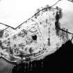
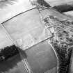
Lynchets at Torwoodlee. On the south-east side of an upland ridge near Torwoodlee Broch, almost entirely between the 700 and 800 ft. contours, are the remains of several lynchets. To the east, they end abruptly in a modern dyke. To the west, they merge into the field, but distinct traces of their having originally been carried the complete width of this field and the next field west still remain.
The banks are very wide, in some places, nearly 40feet, and the height between negative and positive is at some points as much as 7 feet. Two small lynchets situated between the 775 and 800 ft. contours are marked as a continuation of the rampart of the fort in both the original plan prepared by J. Curle in 1891, and also upon the six-inch Ordnance map. However, upon close examination it would appear that they in no part ever formed a contination of the defences of the fort.
H E Kilbride-Jones and M E C Mitchell 1933
Centred NT 46603830. Three or four poorly defined fragments of lynchets are visible. The remains are in a much wasted condition; the best preserved portions on the lower slopes are situated within an area of rough pasture. The lowest lynchet, and another about 50m above it, can be seen, from a distance, to extend further Westwards, but these courses cannot be surveyed. The height of the lynchets vary from 0.5m to 3.0m.
Visited by OS (WDJ) 10 January 1961
Sbc Note
Visibility: This is an upstanding earthwork or monument.
Information from Scottish Borders Council

