
Inveresk, Musselburgh


Aqueduct (Roman)(Possible), Enclosure (Roman)
Site Name Inveresk, Musselburgh
Classification Aqueduct (Roman)(Possible), Enclosure (Roman)
Canmore ID 53853
Site Number NT37SW 21
NGR NT 3497 7196
Datum OSGB36 - NGR
Permalink http://canmore.org.uk/site/53853


- Council East Lothian
- Parish Inveresk (East Lothian)
- Former Region Lothian
- Former District East Lothian
- Former County Midlothian
Trial Trench (1963 - 1966)
NT37SW 21 3497 7196.
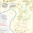
(Centred NT 349 719) A defensive system, apparently of a permanent structure, first noted in 1961, when it was thought to belong to a Flavian fort, was located by trenching by Dr St Joseph in 1963-6. It consisted of the remains of a rampart and three ditches. The outermost and middle ditches, separated by a 19' berm, were both 11' wide and 6' deep; after a 16' berm came the inner ditch, 7' wide and 5 3/4' deep, containing tumbled turf from the rampart.
The most southerly point located was in a nursery garden (NT 349 718) where the ditches appeared to be turning west as if to form the angle of a fort, but from this point they ran northwards for 700' through a narrow field (NT 349 719) and into the playing-field south of Lewisvale Park (NT 349 719) before being broken by a causeway at least 60' wide at whose southern edge a short cross-ditch linked the three ditches. North of the causeway the ditches were traced for another hundred feet. From what would have been the enceinte, 1st c pottery was recovered but none of it was Flavian.
The implied dimensions of a fort enclosed by this system would be much greater than those of any known auxiliary fort in Scotland, and there is not room for such between the known defences and the river; so it is possible that they belong to an annexe or a stores base of the Antonine fort (NT37SW 8).
D R Wilson and R P Wright 1964; 1967; J K St Joseph 1964; 1965
Trial Trench (27 September 1965 - 2 October 1965)
NT37SW 39 3482 7212.
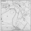
Excavations carried out in 1965 by J K St Joseph at NT 348 721 in a field N of the playing field attached to Lewisvale Public Park revealed a ditch 6-10' wide and 275' long, forming the N side, and 140' of the E side of an apparently rectangular enclosure. A 12' wide causeway lay centrally in the N side. A second ditch, 5' wide, identified as the water-pipe channel supplying the Antonine bath-house (NT37SW 13), now largely robbed of its original stone lining, ran obliquely across the enclosure for 400'. The enclosure is distinct from the triple ditch NT37SW 21.
D R Wilson 1966; 1967
Trial Trench (26 October 1966 - 30 October 1966)
The most prominent of the linear cropmarks previously reported (St Joseph 1965) has been excavated and found to be a large V-shaped ditch, 6' deep, and characteristically Roman type. Cropmarks establish two sectors of its course, 975ft and 625ft in length, inclined at an obtuse angle, probably defining the NW and W sides of a larege camp, lying on carefully chosen ground protected on these sides by a scarp sloping down to the River Esk, and to the E by the extensive Howe Mire, now converted to arable land. Repeated search has failed to reveal a corresponding ditch to E and SE. However the E-W dimension is unlikely to be less than 1550ft, and there is space for a camp of the largest size. The position is six miles from Pathhead, and it may be noted that this is the last space S of the fort in Inveresk village on which it is possible to lay out, on level ground, a camp of 120 acres or more.
J K St Joseph 1969
Trial Trench (26 September 1966 - 30 September 1966)
NT37SW 39 3482 7212.
Excavations carried out in 1965 by J K St Joseph at NT 348 721 in a field N of the playing field attached to Lewisvale Public Park revealed a ditch 6-10' wide and 275' long, forming the N side, and 140' of the E side of an apparently rectangular enclosure. A 12' wide causeway lay centrally in the N side. A second ditch, 5' wide, identified as the water-pipe channel supplying the Antonine bath-house (NT37SW 13), now largely robbed of its original stone lining, ran obliquely across the enclosure for 400'. The enclosure is distinct from the triple ditch NT37SW 21.
D R Wilson 1966; 1967
Field Visit (12 April 1975)
The area this work covers is occupied by a cemetery and a garden centre. No trace appears on the surface.
Visited by OS (SFS) 12 April 1975
Note (November 1985)
Feature is probably part of the civilian settlement.
Information from G Maxwell, November 1985.
Aerial Photographic Interpretation (September 1987)
This feature is best recorded on two CUCAP photographs taken before the field at NT349 719 was turned into allotments.
Information from RCAHMS (CAA) September 1987
Note (September 1987)
Pottery recovered was in fact of Antonine date (Late South Gaulish).
Information from G Maxwell, September 1987
Excavation (October 1989 - November 1989)
NT 350 718. An excavation was carried out during October/November 1989 by APG in advance of a proposed housing development at Crookston Road, Inveresk, on part of an extensive field system, occupying a ridge to the E and SE of the Roman fort of Inveresk (NT37SW 8), in the S of the scheduled area, between Lewisvale Public Park and Edenhall Hospital. Aerial photographs had shown cropmarks indicative of the boundary ditches of a field system, and the continuation of a triple-ditched feature (NT37SW 21), visible as a cropmark in the adjacent field to the N and investigated by Professor St Joseph in the 1960s.
Geophysical survey preceded excavation of a trench c200m long by 5m wide, SE of and parallel to the edge of the scheduled area, and a 300 square metre area at the NW end of the trench, where it was expected the triple-ditched feature would lie. The overburden was found to be up to 1.5m deep at the NW end of the field; this yielded large quantities of predominantly modern material.
The two outermost ditches of the triple-ditched feature were located in the excavated area. These revealed V-shaped profiles, the "middle" ditch having a relatively well-defined "ankle-break". One sherd of Samian ware (Dr 37) lay on the top of the fill of this ditch. There was no obvious indication of collapsed turf in the fill of the ditches, which seem to have lain open for some time.
The excavation remains were commensurate with the cropmark evidence and seem likely to represent the remains of old boundary ditches. A base sherd of Samian ware (Dr 37) was found in one ditch and 8 sherds of Black Burnished ware (BB 1) and a sherd of Samian were found in one of a group of pits.
Sponsors: HBM, Woodroy Ltd.
A F Leslie 1990.
Unspecified Geophysical Survey Technique (1989)
Geophysical survey was undertaken prior to an archaeological excavation in advance of a housing development at Crookstown Road, Inveresk. The area investigated covered part of the extensive field-system to the S of the Roman Vicus at Inveresk and included the southward continuation of a triple ditch feature (NT37SW 21). The geophysical survey proved to be archaeologically unrewarding.
A Leslie 2002

