
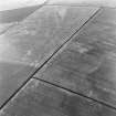
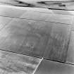
Falside Hill


Field Boundary(S) (Period Unknown)
Site Name Falside Hill
Classification Field Boundary(S) (Period Unknown)
Canmore ID 53701
Site Number NT37SE 57
NGR NT 38543 72036
Datum OSGB36 - NGR
Permalink http://canmore.org.uk/site/53701


- Council East Lothian
- Parish Tranent
- Former Region Lothian
- Former District East Lothian
- Former County East Lothian
NT37SE 57 NT 38543 72036
Ploughed down field boundaries have been recorded as cropmarks on oblique aerial photographs (RCAHMSAP 1976) lying on the N flank of Falside Hill.
Information from RCAHMS (DCC) 7 February 2007

