
Battle Of Pinkie, Howe Mire


Battle Site (16th Century), Cremation Pit (Prehistoric)(Possible), Linear Feature(S) (Period Unknown), Oven (Roman), Roundhouse(S) (Prehistoric), Arrowhead(S) (Period Unknown)(Possible), Button(S) (19th Century), Coin(S) (18th Century), Nail(S) (Period Unknown), Shot(S) (Lead)(16th Century)
Site Name Battle Of Pinkie, Howe Mire
Classification Battle Site (16th Century), Cremation Pit (Prehistoric)(Possible), Linear Feature(S) (Period Unknown), Oven (Roman), Roundhouse(S) (Prehistoric), Arrowhead(S) (Period Unknown)(Possible), Button(S) (19th Century), Coin(S) (18th Century), Nail(S) (Period Unknown), Shot(S) (Lead)(16th Century)
Alternative Name(s) Wallyford; Musselburgh
Canmore ID 53680
Site Number NT37SE 38
NGR NT 3610 7150
NGR Description Centred NT 3610 7150
Datum OSGB36 - NGR
Permalink http://canmore.org.uk/site/53680


- Council East Lothian
- Parish Inveresk (East Lothian)
- Former Region Lothian
- Former District East Lothian
- Former County Midlothian
centred 3610 7150
(Name: NT 361 715) Site of the (NAT) Battle of Pinkie (NR)
10th September 1547 (NAT)
OS 1:10000 map (1973).
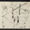
The battle of Pinkie was fought between an English army, led by Protector Somerset, and a Scottish army under the Earl of Arran, their numbers being as indicated by Groome (1901). A skirmish was fought on the 9th September 1547 at the E end of Musselburgh links, and the main battle was fought the following day, the armies taking up the positions shown on plan. The Scottish army was routed.
The Ordnance Survey Name Book [ONB] refers to large quantities of human bones, pieces of spears, swords, horse-shoes and officers' epaulettes having been found in the area indicated.
W Patton 1798; Name Book 1853; OS 6" map (1855).
This battlefield was included in a nation-wide study of key battle sites. A detailed gazetteer was created by The Battlefield Trust, which includes an historical overview of each site, detailed assessments of the action and its location and the number of troops involved, casualties, sources of information and an interpretation of the events and its impact on history.
(For more detail see the gazetteer and associated materials).
NMRS, MS/2522.
The battlefield can be crudely defined with a secure boundary of the Esk on the W, to the SE Falside Hill provides a boundary, while Musselburgh gives a northern boundary. This wide definition is only broadly indicative of where the battle was fought.
G Foard, T Partida 2005.
Metal Detector Survey (2005 - 2006)
In 2005 and 2006 a series of formal metal detector surveys were undertaken on two fields to the immediate west and south-west of Barbachlaw Farm, Wallyford. These two fields are situated within the 16th century Battle of Pinkie (1547) landscape and within what is believed to be the core area of conflict.
A total of four surveys were undertaken under different vegetation conditions. A large number of artefacts were recovered, a small percentage of which were comprised of artillery shot and interpreted as being associated with the Battle of Pinkie.
B Simpson, East Lothian Council 2011
Metal Detector Survey (22 April 2007 - 8 July 2007)
NT 3618 7150 We undertook archaeological works were undertaken on a 15ha field between 22 April 2007 and 8 July 2007. The works were commissioned as part of a phased investigation of the archaeological potential of the site. Of principal note was the juxtaposition of the site to the Battle of Pinkie (10 September 1547).
An initial metal detecting survey using volunteers from the S.A.R.G metal detecting club recovered 150 metal objects including 15 lead shot of various sizes, some of which may be associated with the Battle of Pinkie. Other finds included two probable cannon shots, possible arrowheads, 18th- to 19th century coins and tokens, and a 19th-century military button.
A subsequent test pitting programme involving the excavation of 100 test pits was informed by the distribution of the artefacts recovered during the initial metal detecting survey. A further 50 metal artefacts were retrieved including buttons, coins and nails. Large amounts of Victorian and modern ceramics were noted but not recovered. No lithic artefacts or prehistoric pottery sherds were found.
The intrusive archaeological evaluation targeted areas of possible archaeological interest illustrated by the previous surveys.
The evaluation revealed a substantial number of archaeological features including a probable cremation pit, a ring-grooved roundhouse, a truncated roundhouse and several linear features, all of probable prehistoric date. In addition a figure-of-eight Roman field oven was found with possibly associated features, and a large number of isolated pit features of unknown date and function were also observed.
A further programme of metal detecting was undertaken as part of the evaluation. This produced a further 297 metal artefacts including the firing mechanism of a cap and ball pistol.
Archive to be deposited with RCAHMS.
Funder: Sirius Ltd.
Test Pit Survey (22 April 2007 - 8 July 2007)
NT 3618 7150 We undertook archaeological works were undertaken on a 15ha field between 22 April 2007 and 8 July 2007. The works were commissioned as part of a phased investigation of the archaeological potential of the site. Of principal note was the juxtaposition of the site to the Battle of Pinkie (10 September 1547).
An initial metal detecting survey using volunteers from the S.A.R.G metal detecting club recovered 150 metal objects including 15 lead shot of various sizes, some of which may be associated with the Battle of Pinkie. Other finds included two probable cannon shots, possible arrowheads, 18th- to 19th century coins and tokens, and a 19th-century military button.
A subsequent test pitting programme involving the excavation of 100 test pits was informed by the distribution of the artefacts recovered during the initial metal detecting survey. A further 50 metal artefacts were retrieved including buttons, coins and nails. Large amounts of Victorian and modern ceramics were noted but not recovered. No lithic artefacts or prehistoric pottery sherds were found.
The intrusive archaeological evaluation targeted areas of possible archaeological interest illustrated by the previous surveys.
The evaluation revealed a substantial number of archaeological features including a probable cremation pit, a ring-grooved roundhouse, a truncated roundhouse and several linear features, all of probable prehistoric date. In addition a figure-of-eight Roman field oven was found with possibly associated features, and a large number of isolated pit features of unknown date and function were also observed.
A further programme of metal detecting was undertaken as part of the evaluation. This produced a further 297 metal artefacts including the firing mechanism of a cap and ball pistol.
Archive to be deposited with RCAHMS.
Funder: Sirius Ltd.
Metal Detector Survey (20 May 2014)
NT 361 716 A metal detector survey was carried out on 20 May 2014 on a 1.2ha land parcel in advance of the development of a car park. The survey recovered 20 metal artefacts and 2 gun flints. The finds included a Victorian farthing and token, several buttons of probable 19th/20th-century date, possible horse harness equipment, an iron tool, a lead seal and a possible decorative mount. The majority of the finds were relatively modern. Further analysis of two lead objects established that they are 18th- or 19th-century in date, and not related to the 16th-century battle that took place in this area.
Archive: RCAHMS (intended)
Funder: Sirius Leisure Ltd
Rob Engl – AOC Archaeology Group
(Source: DES)
OASIS ID: aocarcha1-179663

