
Bankhead


Linear Feature(S) (Period Unknown), Settlement (Period Unknown)
Site Name Bankhead
Classification Linear Feature(S) (Period Unknown), Settlement (Period Unknown)
Canmore ID 53670
Site Number NT37SE 29
NGR NT 39236 72816
Datum OSGB36 - NGR
Permalink http://canmore.org.uk/site/53670


- Council East Lothian
- Parish Tranent
- Former Region Lothian
- Former District East Lothian
- Former County East Lothian
NT37SE 29 NT 39236 72816
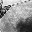
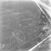
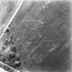
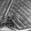
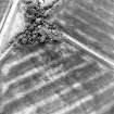
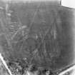
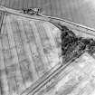
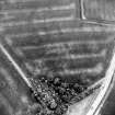
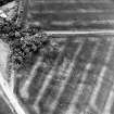
(NT 3923 7281) Two oval-shaped crop marks, one within the other, are visible on aerial photographs (RAF:541/570:3006-7, flown 1950).
(Undated) information in NMRS.
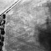
This crop marks falls on a natural terrace. No trace exists. No further information.
Visited by OS (SFS) 26 August 1975
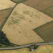
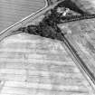
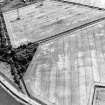
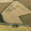
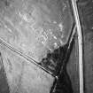
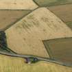
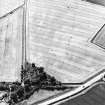
Enclosure, Bankhead: visible on RCAHMS aerial photographs.
(Undated) information in NMRS.
This settlement has been recorded as cropmarks on oblique aerial photography (RCAHMSAP 1978, 1979, 2000) lying on the NE flank of Falside Hill. Comprising a broad ditch with an internal palisade and an outer enclosure, the settlement is roughly oval on plan with an entrance on the E. There are amorphous cropmarks in the interior. Linear cropmarks can be seen immediately to the NW and SW of the settlement.
Information from RCAHMS (KMM) 22 June 2004

