
Elphinstone


Settlement (Late Bronze Age)
Site Name Elphinstone
Classification Settlement (Late Bronze Age)
Canmore ID 53397
Site Number NT36NE 68
NGR NT 39575 69938
Datum OSGB36 - NGR
Permalink http://canmore.org.uk/site/53397


- Council East Lothian
- Parish Tranent
- Former Region Lothian
- Former District East Lothian
- Former County East Lothian
NT36NE 68 NT 39575 69938
Note (1 December 2015 - 16 November 2016)
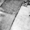
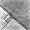
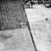
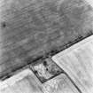
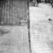
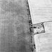
The burial-ground on the gentle slope between Elphinstone Tower and South Elphinstone lies partly within an oval double-ditched enclosure revealed by cropmarks. The burial-ground extends across the perimeter on the W, thus obscuring the course of the ditches on this side, but elsewhere they are about 2m in breadth and are set between 7m and 10m apart, enclosing an area measuring about 100m from ESE to WNW by 80m transversely (0.63ha); making some allowance for the presence of an internal bank the interior extends to about 0.55ha. No features are visible within the interior and the position of the entrance is not known.
Information from An Atlas of Hillforts of Great Britain and Ireland – 16 November 2016. Atlas of Hillforts SC3769
Note (March 2017)
Drive-by and Discovery
You are excused when driving out of Edinburgh toward Dunbar along the A1, when close to the Wallyford junction you don’t see the West Mains fort on your right side. Located 700m SE from the A1, the fort lies in fields around West Mains farm. The fort is positioned on a raised area, slightly upslope from the A1. And even though it is 200m in diameter, with four concentric ditches, and two ramparts, it is nevertheless barely noticeable from the A1 let alone when standing in the fort itself. This is because it is an archaeological site that is buried, and below ground, denuded by centuries of ploughing. The site is not only enigmatic because it isn’t noticeable, it is also enigmatic because it is only visible under certain conditions. For instance, when the fields have been freshly ploughed, or when particular crops have nearly grown, such as wheat and barley – this produces an image like a photographic negative of the buried archaeology that we call ‘cropmarking’. What is more, the site can only from the air. The dual character of buried archaeology, and the visibility from the air under certain conditions allow archaeologists and others to literally re-imagine the structures and forms of these against what we know about past people and the way that they lived. By re-imagining the West Mains fort from its cropmarking, we can begin not only to put people back into the past, but also for management purposes actively monitor its preservation – it is a Scheduled Monument. Buried archaeology is prone to disturbance, particularly from the plough, and it is important to ensure that a site’s preservation state is periodically checked and assessed.
The site was first ‘discovered’ by O G S Crawford and his pilot, Geoffrey Allington, during a reconnaissance trip into Scotland during June 1939. Flying in a Puss-Moth, the flights were carried out so Crawford’s could carry out his official duties of finishing the third edition of the Ordnance Survey Map of Roman Britain. The flights in June were ‘targeted reconnaissance’, which meant picking up sites associated with the Roman occupation of Britain. Crawford’s particular flying strategy was to fly along Roman roads. And it was probably when flying along the Roman road through East Lothian, parallel and along what is now a combination of the A6124 and A68, that Crawford saw the West Mains fort, some 1.8km east of the Roman road.
Record and Landscape
West Mains fort was entered into the National Historic Environment Record around 1947; a record that was subsequently added to in 1967, 1975, 1976 – 77, 1981 with oblique aerial photographs, and repeat photography in 1986, 1991, 1994, 1995, 1997, 2006, and in 2015. The fort and associated features were mapped in 2008, using one of the oblique aerial photographs taken in 1994. The oblique aerial photography and mapping confirms the initial observations of a multi ditch enclosed settlement or fort, that suggests a later prehistoric, and probably Iron Age, date. The whole circular internal space, defined by the entrance, ditches and banks, is approximately 85m in diameter; ample space for hut circles with small yard spaces. The photography also suggests deeper soil in the internal central area, close to the road. While this has been defined as hut circle, on further inspection of the 2m resolution Airborne Laser Scanning (ALS or lidar) surface model there is a clear depression. Lidar [https://en.wikipedia.org/wiki/Lidar] stands for ‘Light Detection and Ranging’ and is a technology using light sensors to measure the distance between the sensor that’s usually attached to an aircraft, and the target object, which is usually the ground surface, trees as well as buildings. Lidar helps archaeologists to visualize and analyse the ground surface and determine whether there is anything anthropogenic. It is likely that the deeper soil in this depression was formed by quarrying occurring before the 1st edition OS map, perhaps in association with the tower house that lies to the N. The fort has an entrance in the NNE corner of the site, formed by a complex arrangement of ditches and banks. There are hints of a track seen on other oblique aerial photography to the NE.
The fort is part of a broader story about later prehistoric settlement in the area, and the inter-connections that sites such as West Mains fort had with other sites that span across multiple periods of construction and duration. This area of East Lothian has several other similar curvilinear enclosed settlements with multiple ditches and banks, such as Queen Mary's Mount, Fordel Mains and Lawfield. There are also less complex, curvilinear enclosures, perhaps with one or two ditches and banks, such as Birsley Brae, Elphinstone, Padivan, Fuffet Wood, and Lawfield. There are also a large number of rectilinear settlements in the same area, the closest to West Mains fort is at Rigley Hill. All of these enclosures – circular, curvilinear and rectilinear - are approximately dated to the later prehistoric period. They also lie along the same contour level, raised slightly upslope from the coastal plain where the A1 winds its path, and at the interface between this and the flatter, more fertile agricultural land that’s slightly higher than the coastal plain. What the relations are between these different settlements is uncertain, but this area of Scotland, either side of the A1, is a nexus of similarly dated settlements, with overlapping durations and histories. Understanding the relationship between these and the way in which they were connected to different communities and the wider landscape helps us to tell the stories of inhabitation for these later prehistoric people.
Dr Oscar Aldred - Aerial and Remote Sensing Mapping Manager

