
Edinburgh, Holyrood Park, Arthur's Seat, Windy Gowl


Field Boundary(S) (Period Unassigned), Scooped Settlement (Middle Iron Age), Track (Period Unassigned)
Site Name Edinburgh, Holyrood Park, Arthur's Seat, Windy Gowl
Classification Field Boundary(S) (Period Unassigned), Scooped Settlement (Middle Iron Age), Track (Period Unassigned)
Alternative Name(s) Queen's Park
Canmore ID 52555
Site Number NT27SE 88
NGR NT 2781 7247
Datum OSGB36 - NGR
Permalink http://canmore.org.uk/site/52555


- Council Edinburgh, City Of
- Parish Edinburgh (Edinburgh, City Of)
- Former Region Lothian
- Former District City Of Edinburgh
- Former County Midlothian
NT27SE 88 2781 7247.
(NT 2781 7247) Enclosure (NR)
OS 6" map, (1966)
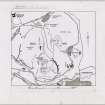
Situated 200 yards (183m) SW of Windy Gowl is a possible medieval scooped enclosure formed by terracing the front to a height of 6' (1.8m) while the bank has been cut over 10' (3m) into the hillside. The enclosing wall is 95' (29m) in diameter. A later road crosses the middle of the enclosure.
R B K Stevenson 1949; RCAHMS 1951.
The enclosing wall of this scooped enclosure has completely vanished apart from at the entrances to the E and W where a slight bank survives. The interior, which measures some 28.0m E-W by 30.0m, is divided by a low scarp into two compartment. An old track runs along this division between the entrances and is partially revetted thus possibly forming the two compartments. No traces of house platforms survive.
Resurveyed at 1:2500.
R B K Stevenson 1949; RCAHMS 1951.
This enclosure is generally as described in the previous field report.
Visited by OS (S F S) 9 December 1975.
Publication Account (1951)
210. Homesteads and Enclosures, King's Park.
In the S.E. corner of the terraced area (RCAHMS 1951 No. 211, i) that faces Dunsapie fort, within the angle formed by the Queen's Drive and at a distance of up to 120 yds. above it, are the remains of three homesteads [NT27SE 87]; they are of a type familiar in the Borders, but as yet rarely reported from N. of the Tweed, which can he described as consisting of a scooped-out enclosure with several floors, often at different levels. They have been described in detail by Mr. R. B. K. Stevenson (1), as follows:(i) An enclosure (Fig. 429D [DP 149972]) measuring 85 ft. in width by 65 ft. from front to back, with a probable entrance in the S.W. corner; the enclosure is subdivided into four, and an annexe impinges upon the N.W. corner. (ii) A second enclosure (Fig. 429E) 35 yds. downhill from the first, measuring 80 ft. in width by 85 ft. from front to back; it also contains four floors. Certain external additions of enclosures and floors have been made to this enclosure. (iii) A third enclosure (Fig. 429F), downhill from the second, has been partly cut away by the Queen's Drive. This also has flanking structures.
In addition to the foregoing, there is also the trace of a small circular structure, lying above the first enclosure. Mr. Stevenson suggests that the uppermost enclosure was superseded by the second one; also, that the enclosures were anterior to some, and contemporary with others, of the cultivation terraces in the vicinity (No. 211). Three other scooped enclosures are noted at other points in the Park. 2 One, a little larger than the second of the three mentioned above, and containing five floors, is situated on the E. side of Dunsapie Crags (Fig. 429G [NT27SE 145]). This enclosure impinges upon a terrace system older than itself. Another, with a diameter of 100 ft., lies 200 yds. S.W. of the Windy Gowl (Fig. 429H [NT27SE 88]), while a third, which is 120 ft. in width by 55 ft. from front to back, lies 130 yds. W. of the Hawse (Fig. 429J [NT27SE 89]). Traces of several floors and external additions can be seen at the last-named site.
RCAHMS 1951, visited c.1941
(1) P.S.A.S., lxxxi (1946-7), pp. 159 ff. (2) Ibid.
OS Map Midlothian iii S.E. (unnoted).
Condition Survey (February 1996)
Survey confirmed the previous description of this scooped enclosure and noted that a path has been worn across the centre of the site along the line of the old trackway causing slight erosion.
Information from Derek Alexander (Centre for Field Archaeology, University of Edinburgh) February 1997
Alexander 1997
Field Visit (15 December 1998)
This enclosure measures 27m in diameter and has been reduced to little more than a scoop into the S-facing hillside some 2m in depth at the rear. The front of the enclosure forms a terrace 1.5m in height, and slight traces of a bank survive on the E and W. Two breaks in the perimeter of the enclosure can be seen, but they coincide with the line of an old track that cuts through the interior. No other internal features are visible, and the low scarp referred to in the NMRS account as dividing the interior into two compartments is no more than the upper edge of this track. The enclosure is almost certainly the remains of a prehistoric settlement.
The enclosure and track, together with several stretches of field-banks that survive on the slopes to the SW, are all plotted at 1:5,550 on an archaeological map of Holyrood Park (RCAHMS 1999).
Visited by RCAHMS (ARG), 15 December 1998.
NMRS, MS/726/96 (46, no. 25); RCAHMS 1999.
Condition Survey (12 March 2018 - 15 April 2018)
The 2018 CFA Archaeology Ltd condition survey found the features very slight and hardly visible on the ground. There was no sign of any walls as mentioned in the NRHE description. The revetted track way is 2.5m wide and runs in a north-west to south-east direction.
Information from Graeme Carruthers (CFA Archaeology Ltd) July 2018. OASIS ID: cfaarcha1-317194, no.25
(Alexander 1997)

