
Following the launch of trove.scot in February 2025 we are now planning the retiral of some of our webservices. Canmore will be switched off on 24th June 2025. Information about the closure can be found on the HES website: Retiral of HES web services | Historic Environment Scotland
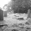
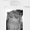
Old Pentland, Burial Ground


Burial Ground (Medieval), Church (13th Century)(Possible), Wall(S) (Medieval), Watch House (18th Century), Unidentified Pottery(S) (Period Unassigned)
Site Name Old Pentland, Burial Ground
Classification Burial Ground (Medieval), Church (13th Century)(Possible), Wall(S) (Medieval), Watch House (18th Century), Unidentified Pottery(S) (Period Unassigned)
Alternative Name(s) Old Pentland Kirk
Canmore ID 51681
Site Number NT26NE 14
NGR NT 26240 66331
Datum OSGB36 - NGR
Permalink http://canmore.org.uk/site/51681


- Council Midlothian
- Parish Lasswade
- Former Region Lothian
- Former District Midlothian
- Former County Midlothian
NT26NE 14.00 26240 66331
NT26NE 14.01 26229 66333 Vault
(NT 2623 6633) Church (NR) (site of)
OS 1:10000 map (1974)
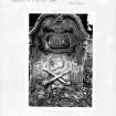
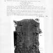
Arnold states that a raised grassy mound in the churchyard covers the ruins of Pentland parish church, while he considered a smaller mound to the E covered the chancel.
Stripping some turf from the latter, he uncovered two 14th c grave slabs. Aitchison notes that the foundations of the church were uncovered a few years before 1892. The church yard was still in use in 1907. Pentland chapel is noted as a free parsonage in Bagimond; it was erected into a parish church before 1275, and the parish was united with Lasswade in 1647.
T Arnold 1880; A Reid 1907; C Aitchison 1892; H Scott 1915; 1950; I B Cowan 1967.
NMRS REFERENCE
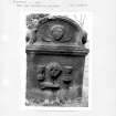
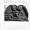
Architect of Gibsone Aisle: Thomas Hamilton c. 1845.
Geophysical Survey (12 September 2009)
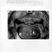
NT 26240 66331 During a geophysical survey of an area in the burial ground directly to the E of the Gibsone Mausoleum on 12 September 2009, distinct traces of buried walls were observed. Investigation of the results using targeted trenches (2 x 2 x 1m) revealed extant foundations and the chamfered course level. 14th- to 16th-century green glaze pottery was recovered and there was evidence of wall robbing, possibly in the 18th century on the basis of later finds. No human remains were recovered. In the church, there was no trace of
a floor, but there was extensive rubble and this area may be investigated further during future geophysical survey of the area to the S, where the distinct outline of a possible second structure has been observed.
Archive: Connolly Heritage Consultancy and RCAHMS
Funder: Connolly Heritage Consultancy
David Connolly – Connolly Heritage Consultancy / Edinburgh Archaeological Field Society
Test Pit Survey (18 September 2010 - 19 September 2010)
NT 26240 66331 Continuing the work undertaken at this site
in 2009 (DES 2009, 120–121), two trenches were excavated
on 18–19 September 2010 to investigate the survival and
shape of the apse at Old Pentland Kirk. The trenches showed
that the entire structure, including the floor, had been
comprehensively robbed. Investigation of a structure to the
S revealed a 19th-century path and graves whose stones had
been removed to allow the construction of the path. A further
geophysical survey to the SW, to investigate the possibility of
a circular enclosure around the churchyard, proved negative.
The pottery recovered during the excavation indicated
activity in the 12th–15th centuries, matching the foundation
date for the kirk and a second period of remodelling work.
Archive: Connolly Heritage Consultancy and RCAHMS
Funder: Connolly Heritage Consultancy

