
Lyne


Fortlet (Roman)
Site Name Lyne
Classification Fortlet (Roman)
Canmore ID 50034
Site Number NT14SE 11
NGR NT 1874 4082
Datum OSGB36 - NGR
Permalink http://canmore.org.uk/site/50034


- Council Scottish Borders, The
- Parish Lyne
- Former Region Borders
- Former District Tweeddale
- Former County Peebles-shire
NT14SE 11 1874 4082.
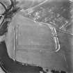
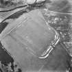
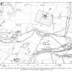
(NT 1874 4082) Roman Fortlet (R) (site of)
OS 6" map (1963)
This fortlet was first recorded by St Joseph on APs. It occupies the crest of a slight rise on the steep W flank of the plateau. Excavations in 1959 showed that it had been defended by a 20' thick turf rampart and a single ditch, and measured c. 90' square internally. Its entrance lay in the centre of the N side. The interior was not explored, due to the destruction of the Roman levels by cultivation, and nothing was found to date the work.
RCAHMS 1967, visited 1963
When field investigated in 1961, the area was under crop, and no trace of the fortlet was found.
Visited by OS (EGC) 28 July 1961
No ground evidence of this fortlet survives.
Surveyed at 1:2500 from APs.
Visited by OS (RD) 22 July 1971
Sbc Note
Visibility: This is an upstanding earthwork or monument.
Information from Scottish Borders Council

