
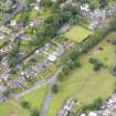
Bo'ness, Grange House


Grange (Medieval)(Possible), House (16th Century)
Site Name Bo'ness, Grange House
Classification Grange (Medieval)(Possible), House (16th Century)
Alternative Name(s) Grange; Grange Hamilton; Grangepans; Old Grange
Canmore ID 49521
Site Number NT08SW 1
NGR NT 00841 81326
Datum OSGB36 - NGR
Permalink http://canmore.org.uk/site/49521


- Council Falkirk
- Parish Bo'ness And Carriden
- Former Region Central
- Former District Falkirk
- Former County West Lothian
NT08SW 1 00841 81326
(NT 00841 81326) Grange House (NR) (1564) Grange House (NR) (site of)
OS 6" map, Linlithgowshire, 1st ed., (1856); OS 25"map, (1972)
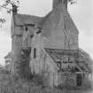
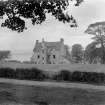
Grange House, which was demolished in 1906, was built in 1564 for Sir John Hamilton. It was a long rectangle on plan, with a square projection near the centre of the S side, containing a staircase.
D MacGibbon and T Ross 1887-92.
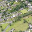
No trace remains of 16th century Grange House. Site now occupied by a modern house and garden.
Visited by OS (J L D) 16 January 1953.
Previous OS field surveyor confirmed.
Visited by OS (B S) 11 March 1974.
Demolished 1906. The house has been known as Grange House, Grangepans, Grange, Old Grange, and Grange Hamilton, and should not be confused with Grange House to the East, NT08SW 33.00 01475 81432.
NMRS PHOTOGRAPHS
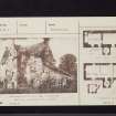
Photographic copies of designs for additions of Old Grange, Bo'ness (see Collection). Scheme by Hippolyte Blanc. With the designs is Blanc's specification and account to Cadell for the cost of surveying Old Grange and preparing the design. Also included is Blanc's acknowledgement of Cadell's account.
EXTERNAL REFERENCE
National Library
Salmon - 'Borrowstoness' p.147-8 - text and photograph
Note (1978)
NT 014 814 NT08SW 1
Site of house built in 1564 and demolished in 1906; one of the traditional sites of the monastic grange of Culross Abbey; the other is at NT08SW 14.
(MacGibbon and Ross 1887-92, iv, 81-4; Salmon 1913, 147-8)
Characterisation
This site falls within the Braehead and The Knowe Area of Townscape Character (NT08SW 166), which was defined as part of the RCAHMS Urban Survey Programme 2013. Text relating to the historical development and topography, and present character of the Braehead and The Knowe Area of Townscape Character can be viewed at site NT08SW 166.
Information from RCAHMS (LK), January 2014

