
Limekilns, Bruce Haven, Capernaum Pier


Pier (18th Century)
Site Name Limekilns, Bruce Haven, Capernaum Pier
Classification Pier (18th Century)
Alternative Name(s) Brucehaven Harbour
Canmore ID 49486
Site Number NT08SE 22
NGR NT 07940 82949
Datum OSGB36 - NGR
Permalink http://canmore.org.uk/site/49486


- Council Fife
- Parish Dunfermline
- Former Region Fife
- Former District Dunfermline
- Former County Fife
NT08SE 22.00 07940 82949
Not to be confused with Limekilns Harbour (Limekilns Pier), for which see NT08SE 23.00.
Location formerly cited as NT 0795 8245.
NT08SE 22.01 NT 07938 82912 Light (Beacon)
Bruce Haven [NAT] (Name centred NT 0808 8296)
Capernaum Pier [NAT] (Name: NT 0794 8293)
OS 1:10,000 map, 1975.
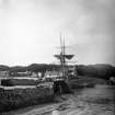
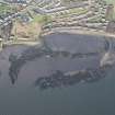
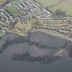
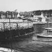
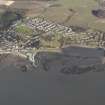
(Location cited as NS [NT] 079 830). Brucehaven, Fife. Cunningham suggests, although not very lucidly, that Brucehaven harbour, formerly known as Capernaum, originated in the 18th century, and Roy's Map of Scotland shows that a pier existed there before 1755.
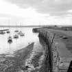
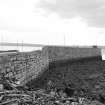
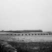
As it stands, the pier shows no obvious dating features, but it might well go back to Roy's time. It is based on a projecting rock, runs SSW for 280ft [85.4m] on a slightly sinuous line, and then swings E of S for its final 100ft [30.5m], its average breadth being about 25ft [7.6m]. Its W face is of squared, well-coursed, blocks, the parapet being of a different build in smaller and rougher material; about the middle of the final curve the parapet formerly contained a door-like opening, perhaps for access to steps, but this has been built up nearly to the height of the parapet, and now forms a kind of shallow embrasure. The E face is less well coursed and shows some vertical slabs at the top, probably representing a repair. Near the landward end, on the E, a flight of rock-cut steps descends to the beach.
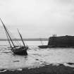
The pier gives shelter from the W to the harbour area, a pocket of tidal sand which widens out at its inner end. A longish stretch of the flat rocks that flank it on the E has been cut back to a straight face, and at least one large mooring-ring and the fitting for another survive there. The entrance was protected from the E by a detached breakwater, about 130ft [39.6m] long, which stands on the rocks abouit 180ft [54.9m] SE of the pier-head. It is built of large blocks, but is largely ruinous, except for the lowermost courses.
A Graham 1971.
(Location cited as NT 079 830). Pier, probably 18th century. L-plan coursed-rubble pier, forming a basin with a natural reef and a short stretch of artificial breakwater.
J R Hume 1976.
Site recorded by Maritime Fife during the Coastal Assessment Survey for Historic Scotland, Kincardine to Fife Ness 1996
The location assigned to this record defines the approximate midpoint of the structure. The available map evidence (OS AIB GIS) indicates that it extends from NT 07941 82909 to NT c. 07976 83021.
Information from RCAHMS (RJCM), 31 March 2006.

