
Following the launch of trove.scot in February 2025 we are now planning the retiral of some of our webservices. Canmore will be switched off on 24th June 2025. Information about the closure can be found on the HES website: Retiral of HES web services | Historic Environment Scotland
Moffat, Chapel, St Cuthbert's Chapel


Architectural Fragment(S) (Period Unknown), Bank (Earthwork)(S) (Period Unknown), Chapel (13th Century)(Possible), Tower House (Medieval)
Site Name Moffat, Chapel, St Cuthbert's Chapel
Classification Architectural Fragment(S) (Period Unknown), Bank (Earthwork)(S) (Period Unknown), Chapel (13th Century)(Possible), Tower House (Medieval)
Alternative Name(s) Chapel Farm; Chapel, Remains Of St Cuthbert's Chapel And Related Structures
Canmore ID 48328
Site Number NT00NE 11
NGR NT 07389 05492
Datum OSGB36 - NGR
Permalink http://canmore.org.uk/site/48328


- Council Dumfries And Galloway
- Parish Kirkpatrick-juxta
- Former Region Dumfries And Galloway
- Former District Annandale And Eskdale
- Former County Dumfries-shire
NT00NE 11 07389 05492
(NT 0739 0551) Chapel (NR)
OS 6" map, (1957)
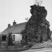
See also NT00NE 84 for farm cottages adjoining ruins, which incorporate the Eastern gable of the chapel.
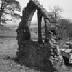
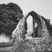
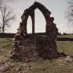
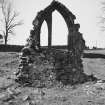
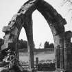
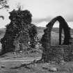
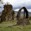
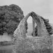
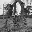
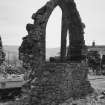
The 13th century chapel of St Cuthbert, traditionally said to have been built by the Knights Templars who for a long time held the lands of Chapel, Craikscraigs, Gardenholm and Holehouse (Keddie 1855) was apparently oblong on plan, 21'6" by 44'9". All that remained in 1912 was the W gable, which contained a pointed arched doorway, and a fragment of the E gable. Keddie adds, 'there are remains of extensive buildings close by to which the chapel was attached.'
RCAHMS 1920, visited 1912
The W and E gables of this chapel are still standing. The tradition still survives, but the dedication could not be confirmed.
To be supplied by Field Surveyor.
Visited by OS (I A) 20 August 1973
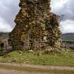
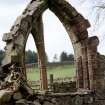
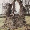
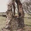
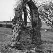
NT 0739 0549. The ruinious, ivy-covered E wall is approximately 7.0m high and 6.0m wide; it has a blocked doorway 2.0m high and 0.9m wide with red sandstone quoins. It forms one end of a small occupied dwelling. The W wall, 4.0m high and 3.0m wide, has a pointed window of red sandstone with fragments of tracery which appears to have been three lancets. Both walls are crudely mortared.
Visited by OS (M J F) 30 August 1978.
Field Visit (14 June 1991)
NT 0739 0551 NT00NE 11
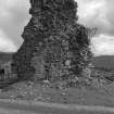
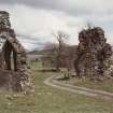
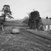
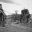
On Chapel farm (NT00NE 84) there are recorded a fragment of a tower, a traceried window of 13th-century date, and a number of earthworks.
All that can be identified of the tower, which has been of at least two storeys, is a fragment of its ENE wall which has been incorporated into the WSW end of a 19th-century cottage. The surviving fragment measures 6.4m in length from NNW to SSE by 2.3m in thickness at the base, which is battered externally on its ENE side. Central to the wall and on the WSW, there is tall arch-pointed door- or window-opening which is probably of composite construction and has latterly been infilled. This is dressed with ashlar and wrought with a chamfered arris which is 100mm broad on the arris of the arch and 50mm on the jambs. The corresponding arch-pointed head of the opening is also apparent in the attic. A lintelled mural passage extends from the SSE side of the arch-pointed opening. It has been partly built up and the interior is choked with rubble, but the passage may be the remains of a mural stair. At the NW angle of the wall there is a mural recess, perhaps the remains of an aumbry.
About 10m to the WSW of the wall-fragment of the tower, and set on a plinth which is probably of 19th-century date, there are the remains of a three-light traceried window with solid spandrels and a weathered sill on its ENE side. A robber trench on the WSW would indicate the former presence of a small enclosure (measuring 6.6m by 3.8m overall) abutting this side of the wall. Since the window has almost certainly been re-constituted in its present position, it is uncertain where the building from which it came originally stood.
To the NW of the upstanding fragment of the tower and bounded by 19th-century field-walls, there are a number of scarps, low banks and shallow gullies; their date and purpose are uncertain.
The remains are said to be those of a chapel, dedicated to St Cuthbert, which is said to have been founded by the Knights Templar; this association is unproven. Keddie, however, adds that 'there are remains of extensive buildings close by to which the chapel was attached'. The traceried window and upstanding wall-fragment are probably derived from an ecclesiastical building, possibly a church or chapel, but the exact character of the tower remains uncertain.
Visited by RCAHMS (IMS), 14 June 1991.
(W Keddie 1855).
Listed as tower, chapel and hospital (possible).
RCAHMS 1997.
Measured Survey (12 March 1991)
RCAHMS surveyed the tower house and earthwork at Chapel on 12 March 1991 with plane-table and self-reducing alidade, producing a plan at a scale of 1:500.

