
Scheduled Maintenance
Please be advised that this website will undergo scheduled maintenance on the following dates: •
Tuesday 3rd December 11:00-15:00
During these times, some services may be temporarily unavailable. We apologise for any inconvenience this may cause.
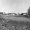
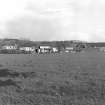
Dollar Mine


Colliery (Period Unassigned)
Site Name Dollar Mine
Classification Colliery (Period Unassigned)
Alternative Name(s) West Pitgober Coal Mine
Canmore ID 48242
Site Number NS99NE 31
NGR NS 9709 9797
Datum OSGB36 - NGR
Permalink http://canmore.org.uk/site/48242


- Council Clackmannan
- Parish Muckhart (Clackmannan)
- Former Region Central
- Former District Clackmannan
- Former County Perthshire
NS99NE 31 centred 9709 9797
DOLLAR Colliery
Note: Although the surface arrangement is itself a few hundred metres inside Perthshire, the underground workings extend under Clackmannanshire.
Location: Dollar
Previous Owners: Alloa Coal Company
Types of Coal: Steam and House, latterly Upper Hirst
Sinking/Production Commenced: 1943
Year Closed: 1973
Year Abandoned: no data
Average Workforce: 135
Peak Workforce: 454
Peak Year: 1963
Shaft/Mine Details: 3 surface mines, gradient 1 in 9. Mines No. 1 and 3 at NS 9706 9979, and Mine No. 2 at NS 9703 9803.
Details in 1948: Output 180 tons per day, 45,000 tons per year. 89 employees. Dross sent to Devon colliery (NS89NE 40.01) for washing. No baths or canteen. First-aid room. AC electricity provided by Devon Colliery. Report dated 25-08-1948.
Other Details: Mines 4 and 5 were driven by the National Coal Board (NCB) from 1956, entering production in 1960. A highly productive pit, it was never connected underground to the Longannet complex, but did supply Kincardine Power Station (NS98NW 61.00).
M K Oglethorpe 2006.

