
Menstrie Castle


Fortified House (Period Unassigned), House(S) (17th Century)
Site Name Menstrie Castle
Classification Fortified House (Period Unassigned), House(S) (17th Century)
Alternative Name(s) Castle Road, 1 - 2 Castle Court
Canmore ID 47125
Site Number NS89NW 21
NGR NS 84940 96858
Datum OSGB36 - NGR
Permalink http://canmore.org.uk/site/47125


- Council Clackmannan
- Parish Alva
- Former Region Central
- Former District Clackmannan
- Former County Clackmannanshire
NS89NW 21.00 84940 96858
NS89NW 21.01 84940 96870 North wing
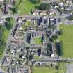
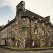
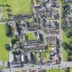
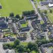
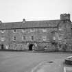
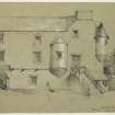
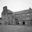
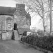
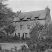
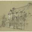
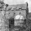
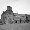
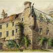
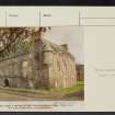
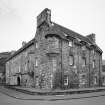
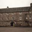
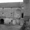
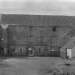
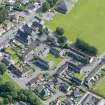
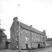
Menstrie Castle stands on the southern side of the village. It dates from the late 16th and early 17th centuries. The house appears originally to have been quite a small L-shaped fortalice, but later the wing was extended, another wing was added and a curtain wall erected to the east to join up, thus enclosing quite a large courtyard. Only the west and south wings of the original house now remain. The gables are crowstepped and an angle-turret with gunloops crowns the south-east corner.
Menstrie was burned by Montrose in 1645. In 1963 the building was restored. Two rooms were dedicated to commemorate the link between Scotland and Novia Scotia. It also contains four flats let by the Council and is surrounded by modern housing.
RCAHMS 1933; N Tranter 1963
Located at NS 8494 9685.
Visited by OS Reviser, November 1984.
NMRS REFERNCE:
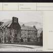
Schomeberg Scott plans: Commemoration Room for the Baronets of Nove Scotia.
Field Visit (2 May 1928)
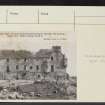
Menstrie Castle.
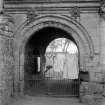
The remains of "the house of Menstrie " stand on the southern side of the village, and one portion of it is still inhabited. The building (SC 1057041) evidently dates from the early 17th century, and has originally consisted of a main block, lying north and south, with a wing running eastward at either end. Only the main block and the south wing have survived. These have apparently been of three storeys throughout, but the wall-head of the main block is slightly higher than that of the wing, the uppermost windows of which are therefore dormers. The masonry is of rubble, harled, and the gables are crow-stepped. At the south-west angle is a turret resting on corbels and having a quatrefoiled loop aligned along the south wall of the wing. In the centre of the main block a vaulted pend or arched passage, lying between two vaulted chambers, leads to a courtyard, now a farmyard. The entrance to the passage is a moulded archway, the archivolt of which is enriched with the cable ornament and surmounted by an entablature. On each side of it is a bench, and on one side a locker.
In the southern re-entrant angle is a circular stair-tower, now slightly reduced from its original height, and in the re-entrant angle opposite there has been a forestair, rising to a moulded doorway, still in situ, on the first floor of the main block. On the lower part of the east or inner face of the main block is a moulded string with eight cannon-shaped spouts.
HISTORICAL NOTE. - The house was burnt in August 1645 by the Marquis of Argyll and the Covenanting army as they followed in the track of the Marquis of Montrose (1) to suffer defeat at Kilsyth. It then belonged to the Earl of Stirling, but, as the result of a process of "apprising," the lands and "manor-house" became in 1648 the property of "General Major Howburne," or Holborne, a commander in the army of the Covenanters (2). The Holbornes held Menstrie till 1719, when the estate was sold to Alexander Abercromby of Tullibody (3).
RCAHMS 1933, visited 2 May 1928.
(1) The Memoirs of Bishop Guthrie (ed. 1747), p. 193. (2) MS. General Register of Sasines, lx,f. 200. (3) Logie, a Parish History, by R. Menzies Fergusson, ii, p. 172.
Photographic Survey (1956)
Photographic survey by the Scottish National Buildings Record in 1956.
Reference (February 2013 - February 2013)
Menstrie Castle dates from the late 16th to early 17th century, and was described by Groome (1885) as “a quaint old house...the birthplace of the poet Sir William Alexander (1580-1640), first Earl of Stirling and also Sir Ralph Abercromby (1734-1801), the hero of Aboukir Bay.” Originally the structure appears to have been a small fortifies house which was later extended by the addition of wings to the north and east. The original house formed the south-west corner of the courtyard enclosed on the other sides by later additions and ancillary structures while the eastern side was enclosed by a stone wall. The oldest part of the building appears to be on the southern side where thee gables are crow-stepped and there is a corbelled out bartizan tower with gun-loops. Such defensive measures were not simply for show as the castle was reputedly attacked and burnt by Montrose in 1645. The building was occupied up to the 1950s by which time it had become largely ruinous. The National Trust for Scotland in co-operation with Clackmannanshire County Council played a large part in saving the building from demolition and in 1963 it was restored.
Historic maps help with the understanding of the development of Menstrie. Adair’s maps of 1681 and 1688 names “Menstry” as being separate from the village. Roy’s (1750) map shows an L-shaped structure aligned north-south with a wing attached to the north-east side. It also shows a large tree lined enclosure to the north of the castle with the village beyond and what appears to be a sub-divided enclosure, possibly gardens, to the south.
On the 1st edition Ordnance Survey map (1863) the Castle is shown very clearly as ‘Menstry Place’ and consists of an L-shaped building forming the south and west sides of a courtyard with a couple of small outbuildings attached to the north side. The areas to the south and north are either gardens or orchards. On the 2nd edition the orchard to the south has been removed and the southern side of the courtyards has been extended eastwards by another building. There are also two structures added to the north side of the courtyard. The 1922 edition shows much the same as the 2nd edition. On the 1969 OS map only the western side of the courtyard survives; the buildings having been replaced by new housing.
Information from NTS

