|
Prints and Drawings |
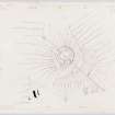
DBD 4/1 |
Records of the Royal Commission on the Ancient and Historical Monuments of Scotland (RCAHMS), Edinbu |
Plane-table survey: dun at Dumbuie. |
19/5/1955 |
Item Level |
|
|
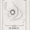
Prints and Drawings |
DBD 4/2 |
Records of the Royal Commission on the Ancient and Historical Monuments of Scotland (RCAHMS), Edinbu |
Inked plan: dun at Dumbuie. |
c. 1955 |
Item Level |
|
|
Manuscripts |
MS 36/175 |
Records of the Royal Commission on the Ancient and Historical Monuments of Scotland (RCAHMS), Edinbu |
Field notebook of K A Steer (RCAHMS). 'S8 - Dumfries, Dumbarton, Kintyre'. |
2/5/1955 |
Item Level |
|
 |
On-line Digital Images |
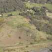
DP 141831 |
RCAHMS Aerial Photography Digital |
Oblique aerial view of Dumbuie Dun, looking N. |
16/4/2012 |
Item Level |
|
 |
On-line Digital Images |
DP 148468 |
Records of the Royal Commission on the Ancient and Historical Monuments of Scotland (RCAHMS), Edinbu |
Plane-table survey: dun at Dumbuie. |
19/5/1955 |
Item Level |
|
 |
On-line Digital Images |
DP 148469 |
Records of the Royal Commission on the Ancient and Historical Monuments of Scotland (RCAHMS), Edinbu |
Inked plan: dun at Dumbuie. |
c. 1955 |
Item Level |
|
 |
Digital Files (Non-image) |
WP 000771 |
Records of the Royal Commission on the Ancient and Historical Monuments of Scotland (RCAHMS), Edinbu |
Scanned copy of RCAHMS Marginal Land Survey unpublished typescripts (Dumbartonshire). |
c. 1955 |
Item Level |
|
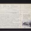 |
On-line Digital Images |
SC 2425942 |
Records of the Ordnance Survey, Southampton, Hampshire, England |
Dumbuie, NS47NW 1, Ordnance Survey index card, page number 1, Recto |
1958 |
Item Level |
|
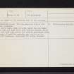 |
On-line Digital Images |
SC 2425943 |
Records of the Ordnance Survey, Southampton, Hampshire, England |
Dumbuie, NS47NW 1, Ordnance Survey index card, page number 2, Verso |
1958 |
Item Level |
|
 |
On-line Digital Images |
SC 2425944 |
Records of the Ordnance Survey, Southampton, Hampshire, England |
Dumbuie, NS47NW 1, Ordnance Survey index card, Recto |
1958 |
Item Level |
|
|
All Other |
551 166/1/1 |
Records of the Ordnance Survey, Southampton, Hampshire, England |
Archaeological site card index ('495' cards) |
1947 |
Sub-Group Level |
|


