
Bute, Muclich Hill


Building (Period Unassigned)(Possible), Hut Circle (Prehistoric)
Site Name Bute, Muclich Hill
Classification Building (Period Unassigned)(Possible), Hut Circle (Prehistoric)
Canmore ID 40479
Site Number NS07SW 14
NGR NS 00780 72667
Datum OSGB36 - NGR
Permalink http://canmore.org.uk/site/40479


- Council Argyll And Bute
- Parish North Bute
- Former Region Strathclyde
- Former District Argyll And Bute
- Former County Buteshire
NS07SW 014 00780 72667.
On SW slope of Muclich Hill, foundations of a platform hut circle 20 by 20m, dug into hillside at E, entrance to NNE with stones standing 0.8m high; 0.5km E, foundations of rectangular hut 16 by 6m, constructed of large irregularly shaped stones.
D {N} Marshall, J M N McCulloch and E McCulloch 1981.
NS 008 726. Muclich West, hut-circle.
Sponsor: Buteshire Natural History Society
A Hannah and E V W Proudfoot 1995
NS 0080 7261 Round structure: Located at foot of SW slope of Muclich Hill, near top of pass leading over from Laggan to top of Glenmore. This is a circular stone structure, c. 6.5m internal diameter. There is a lambing pen built against inner wall-face.
Information from Bute Natural History Society Deserted Settlement Survey (1991-9)
(RCAHMS WP000273)
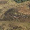
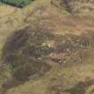
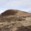
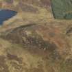
This hut circle is situated in grassy moorland on the N side of the saddle between Muclich Hill, immediately to the N, and Badlia HIll to the SW. It measures about 7m in diameter within a wall 0.8m in thickness and 0.5m in height over internal and external boulder faces. The entrance is on the E, and on its S side there is what may be an external baffle formed by three large contiguous boulders. The interior of the hut circle has been levelled back into the slope to a depth of up to 0.5m on the N and NW, where the facing-stones of the wall have been removed to build two small oval lambing pens.
The 'foundations of a rectangular hut' noted by the previous authority were not found on the date of visit and the site now lies by the Glenmore Burn in a coniferous plantation.
Visited by RCAHMS (GFG, LAD) 31 March 2009.
Field Visit (1981)
On SW slope of Muclich Hill, foundations of a platform hut circle 20 by 20m, dug into hillside at E, entrance to NNE with stones standing 0.8m high; 0.5km E, foundations of rectangular hut 16 by 6m, constructed of large irregularly shaped stones.
D {N} Marshall, J M N McCulloch and E McCulloch 1981.
Field Visit (1991 - 1999)
NS 008 726. Muclich West, hut-circle.
Sponsor: Buteshire Natural History Society
A Hannah and E V W Proudfoot 1995
NS 0080 7261 Round structure: Located at foot of SW slope of Muclich Hill, near top of pass leading over from Laggan to top of Glenmore. This is a circular stone structure, c. 6.5m internal diameter. There is a lambing pen built against inner wall-face.
Information from Bute Natural History Society Deserted Settlement Survey (1991-9)
(RCAHMS WP000273)
Field Visit (31 March 2009)
This hut circle is situated in grassy moorland on the N side of the saddle between Muclich Hill, immediately to the N, and Badlia HIll to the SW. It measures about 7m in diameter within a wall 0.8m in thickness and 0.5m in height over internal and external boulder faces. The entrance is on the E, and on its S side there is what may be an external baffle formed by three large contiguous boulders. The interior of the hut circle has been levelled back into the slope to a depth of up to 0.5m on the N and NW, where the facing-stones of the wall have been removed to build two small oval lambing pens.
The 'foundations of a rectangular hut' noted by the previous authority were not found on the date of visit and the site now lies by the Glenmore Burn in a coniferous plantation.
Visited by RCAHMS (GFG, LAD) 31 March 2009.
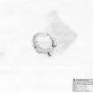
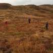
Measured Survey (14 October 2010 - 28 October 2010)
RCAHMS surveyed the hut circle at Muclich Hill, Bute on 14 October 2010 with local volunteers. The survey, undertaken with plane table, self-reducing alidade and tape, produced a plan of the site at a scale of 1:100. The survey drawing was then checked on-site on 28 October 2010.

