
Bute, St Ninian's Bay


Stone Setting (Neolithic) - (Bronze Age)
Site Name Bute, St Ninian's Bay
Classification Stone Setting (Neolithic) - (Bronze Age)
Canmore ID 40426
Site Number NS06SW 10
NGR NS 03700 61778
Datum OSGB36 - NGR
Permalink http://canmore.org.uk/site/40426


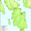

- Council Argyll And Bute
- Parish North Bute
- Former Region Strathclyde
- Former District Argyll And Bute
- Former County Buteshire
NS06SW 10 03700 61778.
(NS 0371 6178) Standing Stones (NR).
OS 6" map (1957)
There are two standing stones near the head of St Ninian's Bay. Very similar in appearance, they are some 46" high, and a similar distance apart.
J Blain 1880
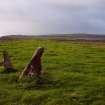
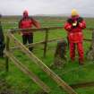
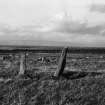
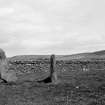
NS 0370 6177. The two standing stones are situated on a level raised beach which forms a narrow peninsula. The northernmost is a pointed angular shaped stone 1.4m high and the other (1.3m to the S) is of similar appearance and 1.0m high.
Surveyed at 1:10,000.
Visited by OS (TRG) 18 November 1976
This site was noted during a coastal zone assessment survey undertaken by CFA Archaeology Ltd to characterise the state of coastal erosion and the threat it poses to cultural heritage sites. A gazetteer in the report included a note of existing records and new sites when discovered. Where the site was located, notes included condition, period/date and recommendations.
Commissioned by The Scape Trust and Firth of Clyde Forum on behalf of Historic Scotland.
Cressey and Johnson 2004
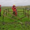
Two stones stand 1.1m apart within a small, wooden-fenced enclosure in rough pasture 480m SW of 'Sea View', Straad. The N stone measures 0.46m in breadth by 0.16m in thickness and 1.1m in height, and it narrows considerably towards the top. The S stone is a slab measuring 0.45m by 0.12m and 0.85m in height.
Visited by RCAHMS (GFG, JH) 6 May 2009.
Field Visit (28 May 1943)
This site was recorded as part of the RCAHMS Emergency Survey, undertaken by Angus Graham and Vere Gordon Childe during World War 2. The project archive has been catalogued during 2013-2014 and the material, which includes notebooks, manuscripts, typescripts, plans and photographs, is now available online.
Information from RCAHMS (GF Geddes) 2 December 2014.
Desk Based Assessment (21 July 1972)
There are two standing stones near the head of St Ninian's Bay. Very similar in appearance, they are some 46" high, and a similar distance apart.
Information from OS (IF) 21 July 1972
J Blain 1880
Field Visit (18 November 1976)
NS 0370 6177. The two standing stones are situated on a level raised beach which forms a narrow peninsula. The northernmost is a pointed angular shaped stone 1.4m high and the other (1.3m to the S) is of similar appearance and 1.0m high.
Surveyed at 1:10,000.
Visited by OS (TRG) 18 November 1976
Field Visit (2004)
This site was noted during a coastal zone assessment survey undertaken by CFA Archaeology Ltd to characterise the state of coastal erosion and the threat it poses to cultural heritage sites. A gazetteer in the report included a note of existing records and new sites when discovered. Where the site was located, notes included condition, period/date and recommendations.
Commissioned by The Scape Trust and Firth of Clyde Forum on behalf of Historic Scotland.
Cressey and Johnson 2004
Field Visit (6 May 2009)
Two stones stand 1.1m apart within a small, wooden-fenced enclosure in rough pasture 480m SW of 'Sea View', Straad. The N stone measures 0.46m in breadth by 0.16m in thickness and 1.1m in height, and it narrows considerably towards the top. The S stone is a slab measuring 0.45m by 0.12m and 0.85m in height.
Visited by RCAHMS (GFG, JH) 6 May 2009.

