
Killaser Castle


Tower House (Medieval)
Site Name Killaser Castle
Classification Tower House (Medieval)
Alternative Name(s) Killasser, Killasor, Killaster, Cairnhandy
Canmore ID 40205
Site Number NX04NE 7
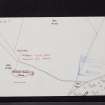
NGR NX 09643 45087
NGR Description Centre
Datum OSGB36 - NGR
Permalink http://canmore.org.uk/site/40205


- Council Dumfries And Galloway
- Parish Stoneykirk
- Former Region Dumfries And Galloway
- Former District Wigtown
- Former County Wigtownshire
NX04NE 7 0964 4509.
(NX 0964 4509) Killaser Castle (NR) (Remains of)
OS 6" map (1957)
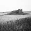
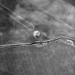
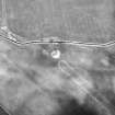
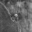
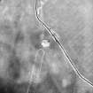
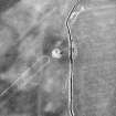
The ruins of Killaser Castle rise from a mound measuring 65' N-S by 63' transversely, formed from the debris of fallen masonry. The Castle was originally a square keep measuring overall about 31' N-S by 28'9" transversely, of which only a portion of the N and E walls now remains, and was probably defended on all sides by a ditch of which there is an indication at the S end.
D MacGibbon and T Ross 1892; RCAHMS 1912, visited 1911.
As described above. The walls, 0.7m thick, rise to a maximum height of 3.0m and the springing of the east side of the vaulted ground floor is also visible. There is now no evidence of a ditch. The mound seems entirely composed of fallen masonry.
Revised at 1/2500.
Visited by OS (WDJ) 8 September 1970
The remains of this tower-house stand within the vestiges of a ditched enclosure in an area of low-lying ground 440m SE of Cairnhandy farmhouse. The rectangular tower (6.5m by 4.8m with a wall up to 2.1m thick) has been reduced to its lowest courses, but enough survives to indicate the presence of a vaulted ground floor, a mural passage and the possible provision for a stair or latrine at the NE angle.
In 1684 Killaser was listed amongst the principle houses in the district, although Symson (in Macfarlane) erroneously states that it stood 1/2 mile E of Ardwell (NX14NW 14).
D MacGibbon and T Ross 1896-7; P H M'Kerlie 1906; RCAHMS 1912; RCAHMS 1985, visited June 1984.
Note (10 December 2021)
The location, classification and period of this site have been reviewed.

