
Escart


Standing Stone(S) (Prehistoric)
Site Name Escart
Classification Standing Stone(S) (Prehistoric)
Canmore ID 39335
Site Number NR86NW 2
NGR NR 8460 6674
Datum OSGB36 - NGR
Permalink http://canmore.org.uk/site/39335


- Council Argyll And Bute
- Parish Kilcalmonell
- Former Region Strathclyde
- Former District Argyll And Bute
- Former County Argyll
NR86NW 2 8460 6674.
(NR 8464 6678) Stone Circle (NR) (Remains of)
OS 6" map (1924)
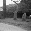
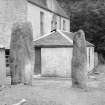
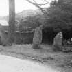
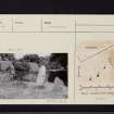
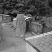
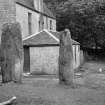
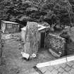
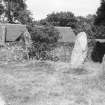
An alignment of 5 standing stones is situated immediately SE of Escart farmhouse. Stone A measures 1.0m x 0.3m at base and rises to a height of 2.85m. Stone B is 3.3m high, and 1.3m x 0.4m at base. Stone C, which has been tilted NE by a tree, is 2.44m high and 0.7 x 0.4m at base. Stone D measures 1.0m x 0.5m at its foot, and 2.06m high. Only part of stone E survives, the top having been broken off when the tree beside C was felled. It now measures 0.8m x 0.25m at base by 1.12m high; originally, it would have been at least 1.5m.
There is some evidence to suggest that there were formerly more stones in the group. A has a charge-hole near the foot of its N face as if it had been prepared for demolition, and the long interval between B and C suggests that a stone may have been removed when the steading wall was built. It may be also be significant that several massive boulders are now incorporated in the lowest course of the wall, and that a drain leading from the NW end of the byre is covered by some very large slabs. RCAHMS 1971, visited 1963
The standing stones are as described by RCAHMS.
Resurveyed at 1:2500.
Visited by OS (DWR) 27 June 1973
Five standing stones as described by the RCAHMS.
Surveyed at 1/10,000.
Visited by OS (BS) 10 March 1977
Said to be a 2nd millenium BC lunar observatory.
A Thom and A S Thom 1979
Field Visit (8 June 1943)
This site was included within the RCAHMS Emergency Survey (1942-3), an unpublished rescue project. Site descriptions, organised by county, vary from short notes to lengthy and full descriptions and are available to view online with contemporary sketches and photographs. The original typescripts, manuscripts, notebooks and photographs can also be consulted in the RCAHMS Search Room.
Information from RCAHMS (GFG) 10 December 2014.

