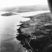
|
Photographs and Off-line Digital Images |
A 53681 PO |
|
Oblique aerial view. |
|
Item Level |
|
|
Photographs and Off-line Digital Images |
AG 1547 |
|
Photographic copy of plan of Castle. |
|
Item Level |
|
|
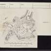
Prints and Drawings |
AGD 542/1 |
Records of the Royal Commission on the Ancient and Historical Monuments of Scotland (RCAHMS), Edinbu |
Plan. Survey RCAHMS. |
1965 |
Item Level |
|
|
Prints and Drawings |
AGD 542/2 |
Records of the Royal Commission on the Ancient and Historical Monuments of Scotland (RCAHMS), Edinbu |
Plan. |
1965 |
Item Level |
|
|
Manuscripts |
MS 4040 |
Records of CFA Archaeology Ltd, archaeologists, Musselburgh, East Lothian, Scotland |
Report: 'Coastal Zone assessment survey Kintyre & Isle of Arran'. |
1/2005 |
Item Level |
|
 |
On-line Digital Images |
SC 1931873 |
|
Oblique aerial view. |
|
Item Level |
|
 |
On-line Digital Images |
SC 2416477 |
Records of the Ordnance Survey, Southampton, Hampshire, England |
Island Muller, NR72SE 4, Ordnance Survey index card, page number 1, Recto |
1958 |
Item Level |
|
 |
On-line Digital Images |
SC 2416478 |
Records of the Ordnance Survey, Southampton, Hampshire, England |
Island Muller, NR72SE 4, Ordnance Survey index card, page number 2, Verso |
1958 |
Item Level |
|
 |
On-line Digital Images |
SC 2416479 |
Records of the Ordnance Survey, Southampton, Hampshire, England |
Island Muller, NR72SE 4, Ordnance Survey index card, page number 3, Recto |
1958 |
Item Level |
|
 |
On-line Digital Images |
SC 2416480 |
Records of the Ordnance Survey, Southampton, Hampshire, England |
Island Muller, NR72SE 4, Ordnance Survey index card, Recto |
1958 |
Item Level |
|
 |
On-line Digital Images |
SC 2416481 |
Records of the Ordnance Survey, Southampton, Hampshire, England |
Island Muller, NR72SE 4, Ordnance Survey index card, Recto |
1958 |
Item Level |
|
|
All Other |
551 30/4/74 |
Records of CFA Archaeology Ltd, archaeologists, Musselburgh, East Lothian, Scotland |
Archive from coastal Zone Assessment Survey of Kintyre and Isle of Arran |
10/2004 |
Sub-Group Level |
|
|
All Other |
551 166/1/1 |
Records of the Ordnance Survey, Southampton, Hampshire, England |
Archaeological site card index ('495' cards) |
1947 |
Sub-Group Level |
|


