
Pricing Change
New pricing for orders of material from this site will come into place shortly. Charges for supply of digital images, digitisation on demand, prints and licensing will be altered.
Campstone Hill, Raedykes


Ring Cairn (Neolithic) - (Bronze Age)(Possible)
Site Name Campstone Hill, Raedykes
Classification Ring Cairn (Neolithic) - (Bronze Age)(Possible)
Alternative Name(s) Raedykes 2
Canmore ID 37184
Site Number NO89SW 8
NGR NO 83271 90608
Datum OSGB36 - NGR
Permalink http://canmore.org.uk/site/37184


- Council Aberdeenshire
- Parish Fetteresso
- Former Region Grampian
- Former District Kincardine And Deeside
- Former County Kincardineshire
NO89SW 8 83271 90608
See also NO89SW 6, NO89SW 7, NO89SW 9.
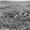
A possible ring-cairn is situated 20m WNW of ring-cairn NO89SW 9; it is oval, measuring 8.5m from NW to SE by 7.7m transversely and 0.5m in height. Several boulders around the perimeter of the cairn may be kerbstones; there is a hollow 3.4m in diameter at the centre, but no trace of any inner kerb and it may be no more than a robbed round cairn. J Ritchie 1923; A S Henshall 1963; RCAHMS 1984, Visited April 1984.
Visible on air photographs AAS/93/07/G17/9-14. Copies held by Grampian Regional Council.
Information from M Greig, Grampian Regional Council, March 1994.
Field Visit (2 May 1957)
This site was included within the RCAHMS Marginal Land Survey (1950-1962), an unpublished rescue project. Site descriptions, organised by county, are available to view online - see the searchable PDF in 'Digital Items'. These vary from short notes, to lengthy and full descriptions. Contemporary plane-table surveys and inked drawings, where available, can be viewed online in most cases - see 'Digital Images'. The original typecripts, notebooks and drawings can also be viewed in the RCAHMS search room.
Information from RCAHMS (GFG) 19 July 2013.
Field Visit (April 1984)
NO89SW 8 8327 90601
Raedykes 2. A possible ring-cairn is situated 20m WNW of ring-cairn NO89SW 9; it is oval, measuring 8.5m from NW to SE by 7.7m transversely and 0.5m in height. Several boulders around the perimeter of the cairn may be kerbstones; there is a hollow 3.4m in diameter at the centre, but no trace of any inner kerb and it may be no more than a robbed round cairn.
RCAHMS 1984, Visited April 1984.
(J Ritchie 1923; A S Henshall 1963)
Measured Survey (15 April 2005)
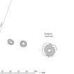
RCAHMS surveyed the Campstone Hill, Raedykes ring cairns on 15 April 2005 with plane table and self-reducing alidade producing a site at a scale of 1:500. The survey drawing was later used as the basis for an illustration produced in ink and finished in vector graphics software at a scale of 1:1000.

