
Pricing Change
New pricing for orders of material from this site will come into place shortly. Charges for supply of digital images, digitisation on demand, prints and licensing will be altered.
Monboddo House


Enclosure(S) (Period Unassigned), Pit(S) (Period Unassigned), Ring Ditch (Period Unassigned), Timber Hall, Unenclosed Settlement (Period Unassigned)
Site Name Monboddo House
Classification Enclosure(S) (Period Unassigned), Pit(S) (Period Unassigned), Ring Ditch (Period Unassigned), Timber Hall, Unenclosed Settlement (Period Unassigned)
Alternative Name(s) Monboddo
Canmore ID 36474
Site Number NO77NW 43
NGR NO 74369 78733
Datum OSGB36 - NGR
Permalink http://canmore.org.uk/site/36474


- Council Aberdeenshire
- Parish Fordoun
- Former Region Grampian
- Former District Kincardine And Deeside
- Former County Kincardineshire
NO77NW 43 7435 7873
Noted by Aberdeenshire Archaeological Service as timber hall.
NMRS, MS/712/17.
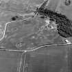
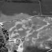
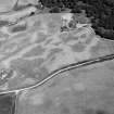
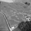
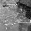
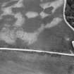
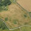
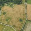
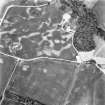
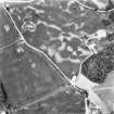
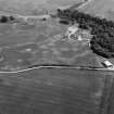
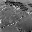
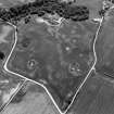
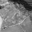
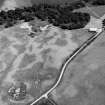
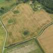
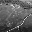
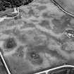
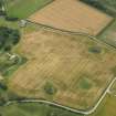
Air photography has recorded the cropmarks including those of a large circular enclosure surrounding a substantial rectangular enclosure. There is a solid circular cropmark (possibly representing a house) in the centre of the field, and a larger circular enclosure (with pits within) adjacent.
(GRC/AAS air photographic cover listed).
NMRS, MS/712/19.
(Location cited as NO 7430 7870: nominated as Site of Regional Significance). This monument is situated on a gentle slope at an altitude of 105m OD. Apart from those noted above, the features represented include a ring-ditch.
[Air photographic imagery listed].
NMRS, MS/712/35.
(Location cited as NO 7440 7880: nominated as Site of Regional Significance). Monboddo House. Air photography (GRC/AAS 1982, 1983, 1984, 1996 and 2000) has recorded the cropmarks of a large circular enclosure surrounding a substantial rectangular enclosure on a gentle slope at an altitude of 105m OD; both traces are very regular. A large circular enclosure with pits within it and a ring-ditch are situated adjacent.
[Air photographic imagery listed].
NMRS, MS/712/96.
Aerial Photographic Transcription (10 April 2012)
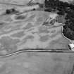
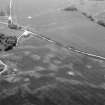
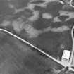
This plantation bank has been recorded as a cropmark on oblique aerial photographs (RCAHMSAP 1982, 1983, 2000, 2008). It is named as Barn Knap and depicted on the 1st and 2nd editions of the OS 6-inch map (Kincardineshire 1868, sheet Ep1_10650_70NO77nw.tif, 1904 sheet Ep2_10650_70NO77nw.tif).
Information from RCAHMS (KHJM) 10 April 2012
Geophysical Survey (11 October 2012 - 12 October 2012)
As part of The Rise and Fall of the Picts: Survey and Excavation at the Early Power Centres and Symbol Stones of Northern Pictland Project an open area evaluation excavation was carried out, 11–12 October 2012, at Monboddo. This site is considered to be of regional significance and aerial photographs taken since 1982 show what appears to be a timber hall and circular enclosure. The site has appeared in many reviews of early medieval settlement. However, the site appears as a circular plantation on the 1st Edition OS map of 1868 and in the same source the knoll upon which the site is located is named ‘Barn Knap’.
A geophysical survey of the site revealed few of the features which are identifiable on the aerial photographs. The survey did identify some concentrated metal signatures on the western part of the site which the excavation area targeted. The machine excavated evaluation trench measured 15 x 20m and covered almost all the western half of the site. The evaluation quickly established that the ‘timber hall’ was the foundation remains of a brick-built post-medieval structure. Four slots were dug through the enclosure ditch and one of these slots produced post-medieval ceramic building material and mortar throughout the profile, suggesting that the enclosure is also a late feature, and probably the remains of the plantation enclosure marked on the 1st Edition OS map. One pit in the enclosure was also half-sectioned revealing a posthole with brick fragments and mortar traces throughout the profile.
Consequently, the Monboddo ‘timber hall’ and enclosure can conclusively be shown to be post-medieval in date and not part of an early medieval or prehistoric tradition of timber halls and enclosures.
Archive: University of Aberdeen (currently)
Funder: British Academy and Carnegie Trust for the Universities of Scotland
G Noble, University of Aberdeen
O Sveinbjarnarson,
C Hatherley,
J Fallgren,
2012

