
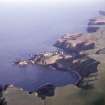
Bowdun Head, Landscape Monitoring Point


General View (21st Century)
Site Name Bowdun Head, Landscape Monitoring Point
Classification General View (21st Century)
Canmore ID 358524
Site Number NO88SE 62
NGR NO 88246 84488
Datum OSGB36 - NGR
Permalink http://canmore.org.uk/site/358524

- Council Aberdeenshire
- Parish Dunnottar
- Former Region Grampian
- Former District Kincardine And Deeside
- Former County Kincardineshire
Project (24 July 2018)
Landscape Monitoring
A programme of landscape monitoring in conjunction with Scottish Natural Heritage and Historic Environment Scotland. The monitoring comprises air photography of selected points across Scotland. The aim of the monitoring is to produce a set of case study locations that will be used to complement the monitoring of Land-use change being carried out as part of the Historic Land-use Assessment.
Information from HES (Survey and Recording) (M Middleton) 2018

